Data
- Obtaining
- Supplying
- High-Frequency
- Bottom Pressure Records
- Other Long Records
- GLOSS/ODINAFRICA Calibration Data
Donate
Donate to PSMSL
Data Notes
- Individual Station Data and Plot Notes
- Referencing the Data Set
- PSMSL Help File
- 2010 Changes to the PSMSL Data Files
Extracted from Database
06 Apr 2026
Station Information
| Station ID: | 1447 |
| Latitude: | 17.693333 |
| Longitude: | -64.753333 |
| Coastline code: | 939 |
| Station code: | 11 |
| Country: | VIRGIN ISLANDS, U.S. |
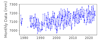
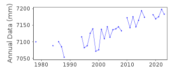
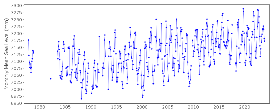
| Time span of data: | 1977 – 2025 |
| Completeness (%): | 84 |
| Date of last update: | 28 Jan 2026 |
| Green Arrow: | Current Station |
| Yellow Marker: | Neighbouring RLR Station |
| Red Marker: | Neighbouring Metric Station |
Please note: In many cases, the station position in our database is accurate to only one minute. Thus, the tide gauge may not appear to be on the coast.
Tide Gauge Data
Additional Data Sources (guide to additional data sources)
Nearby GNSS Stations from SONEL: VIKHNearby Real Time Stations from VLIZ: lime2, stcr, lime, stcr2
Research Quality Data from UHSLC station 254: hourly and daily
Research Quality Data from UHSLC station 258: hourly and daily
Station Documentation
Link to RLR information.Documentation added 2011-12-20
Data for Lime Tree Bay begins in November 1977. Using NOAA data the RLR diagram has been reviewed.Primary benchmark remains 975 1401 M 1983 13.612m relative to Gauge datum.Data Authority
N.O.A.A. / N.O.S.N/oes33, Ssmc4, Room 6531
1305 East-West Highway
Silver Spring,
MD 20910

![]()
![]()
![]()
