Data
- Obtaining
- Supplying
- High-Frequency
- Bottom Pressure Records
- Other Long Records
- GLOSS/ODINAFRICA Calibration Data
Donate
Donate to PSMSL
Data Notes
- Individual Station Data and Plot Notes
- Referencing the Data Set
- PSMSL Help File
- 2010 Changes to the PSMSL Data Files
Extracted from Database
11 Mar 2024
Station Information
| Station ID: | 1371 |
| Latitude: | 1.983333 |
| Longitude: | -157.483333 |
| GLOSS ID: | 146 |
| Coastline code: | 770 |
| Station code: | 22 |
| Country: | KIRIBATI |
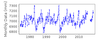
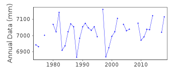
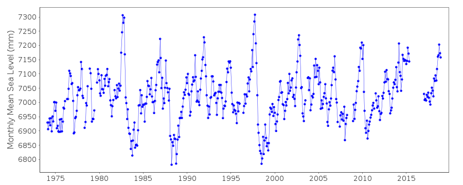
| Time span of data: | 1974 – 2018 |
| Completeness (%): | 92 |
| Date of last update: | 28 Jan 2020 |
| Green Arrow: | Current Station |
| Yellow Marker: | Neighbouring RLR Station |
| Red Marker: | Neighbouring Metric Station |
Please note: In many cases, the station position in our database is accurate to only one minute. Thus, the tide gauge may not appear to be on the coast.
Tide Gauge Data
Additional Data Sources (guide to additional data sources)
Nearby GNSS Stations from SONEL: KRTMFast Delivery Data from UHSLC station 11: hourly and daily
Research Quality Data from UHSLC station 11: hourly and daily
Station Documentation
Link to RLR information.Documentation added 1991-06-11
Christmas Island II 770/022 RLR(1983) is 9.5m below BMUH-1Documentation added 1996-10-07
(1974-present) Leupold and Stevens Analog-to-Digital Recorder (ADR);(11/1982-present) Handar Encoder (ENC)Primary gauge: ADR:1974-90, ENC 1991-Documentation added 2013-10-14
Complete dataset Feb 1974 to April 2012 was loaded onto the database from UHSLCDocumentation added 2014-06-23
Using benchmark information supplied by UHSLC the RLR diagram has been revised. Primary benchmark is now UH2 3.17m above the gauge datum. As a result the RLR factor has changed from 6.476m to 6.330m.Documentation added 2015-10-29
Complete updated JASL data through to 2014 has been loaded onto the database.Data Authority
University of HawaiiDepartment of Oceanography Division of Natural Sciences
1000 Pope Road
Honolulu
Hawaii 96822

![]()
![]()
![]()
