Data
- Obtaining
- Supplying
- High-Frequency
- Bottom Pressure Records
- Other Long Records
- GLOSS/ODINAFRICA Calibration Data
Donate
Donate to PSMSL
Data Notes
- Individual Station Data and Plot Notes
- Referencing the Data Set
- PSMSL Help File
- 2010 Changes to the PSMSL Data Files
Extracted from Database
02 Mar 2026
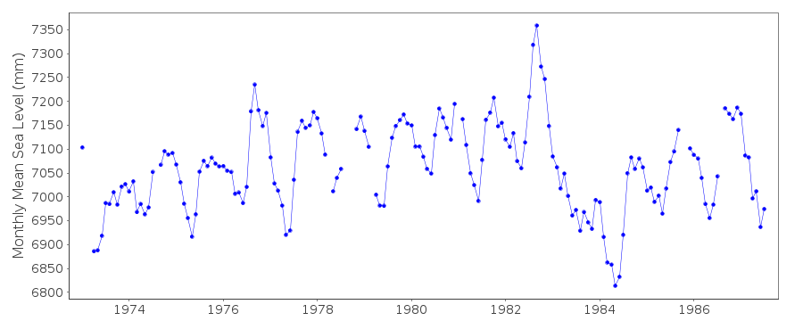
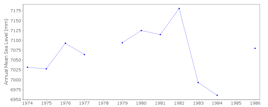
Station Information
| Station ID: | 1361 |
| Latitude: | 3.9 |
| Longitude: | -159.383333 |
| Coastline code: | 770 |
| Station code: | 12 |
| Country: | KIRIBATI |
| Time span of data: | 1973 – 1987 |
| Completeness (%): | 91 |
| Date of last update: | 18 May 1994 |
| Green Arrow: | Current Station |
| Yellow Marker: | Neighbouring RLR Station |
| Red Marker: | Neighbouring Metric Station |
Please note: In many cases, the station position in our database is accurate to only one minute. Thus, the tide gauge may not appear to be on the coast.
Tide Gauge Data
Additional Data Sources (guide to additional data sources)
Research Quality Data from UHSLC station 12: hourly and dailyStation Documentation
Link to RLR information.Documentation added 1994-07-14
Fanning-B 770/012 RLR(1983) is 7.9m below BM UH-2STATION DISCONTINUED IN AUGUST 1987, THERE IS NO LINK TO FANNING-C
Data Authority
University of Hawaii Sea Level CenterDepartment of Oceanography Division of Natural Sciences
1000 Pope Road
Honolulu
Hawaii 96822

![]()
![]()
![]()
