Data
- Obtaining
- Supplying
- High-Frequency
- Bottom Pressure Records
- Other Long Records
- GLOSS/ODINAFRICA Calibration Data
Donate
Donate to PSMSL
Data Notes
- Individual Station Data and Plot Notes
- Referencing the Data Set
- PSMSL Help File
- 2010 Changes to the PSMSL Data Files
Extracted from Database
11 Mar 2024
Station Information
| Station ID: | 1355 |
| Latitude: | 22.883333 |
| Longitude: | -109.9 |
| GLOSS ID: | 161 |
| Coastline code: | 830 |
| Station code: | 20 |
| Country: | MEXICO |
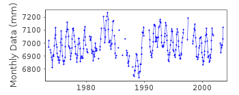
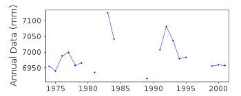
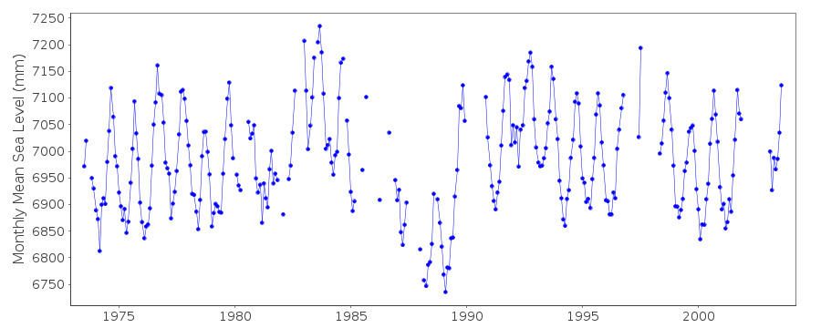
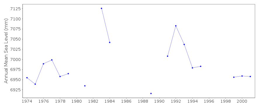
| Time span of data: | 1973 – 2003 |
| Completeness (%): | 76 |
| Date of last update: | 31 Jul 2014 |
| Green Arrow: | Current Station |
| Yellow Marker: | Neighbouring RLR Station |
| Red Marker: | Neighbouring Metric Station |
Please note: In many cases, the station position in our database is accurate to only one minute. Thus, the tide gauge may not appear to be on the coast.
Tide Gauge Data
Additional Data Sources (guide to additional data sources)
Fast Delivery Data from UHSLC station 34: hourly and dailyResearch Quality Data from UHSLC station 34: hourly and daily
Station Documentation
Link to RLR information.Documentation added 1991-06-11
Cabo San Lucas 830/020 RLR(1979) is 9.6m below BM EEA-205Documentation added 1993-11-11
data since 1982 received from TOGA officeDocumentation added 1996-10-08
gauge type: Standard analog (SA) float gauge (1973-1982),Leupold and Stevens Analog-to-Digital Recorder (ADR) model 7001, float gauge (1983+)(Oct 1990-present) Handar Encoder (ENC)Primary gauge: ADR:1974-89, ENC 1990-Documentation added 1997-01-30
Large earthquake offshore of Mexico about 19 degrees North on 9 October 1995 with large tsunami generated. See article by A.E.Filonov in EOS, 78(3), 1997.Documentation added 1997-11-14
The daily and monthly differences with San Diego,San Quintin, and Acapulco hint at anomalously low levels for Cabo San Lucas from Dec 1986 to Aug 1989. However, no clear level shifts canbe identified in the hourly residuals. Otherwise,the data contain gaps but are of good quality.
Documentation added 1999-11-15
data for 1974-81 revised in December 1999Documentation added 2015-12-08
Whole dataset has been received from UH and was part of the TOGA project. Although UH levelling and metadata exist the levelling values given bear no relation to the RLR diagram. Until this has been resolved the diagram has been taken offline.Data Authority
C.I.C.E.S.E.P.O. Box 434844
San Diego
CA 92143-4844

![]()
![]()
![]()
