Data
- Obtaining
- Supplying
- High-Frequency
- Bottom Pressure Records
- Other Long Records
- GLOSS/ODINAFRICA Calibration Data
Donate
Donate to PSMSL
Data Notes
- Individual Station Data and Plot Notes
- Referencing the Data Set
- PSMSL Help File
- 2010 Changes to the PSMSL Data Files
Extracted from Database
08 Dec 2025
WARNING: QCFLAG EXISTS. PLEASE READ THE DOCUMENTATION.
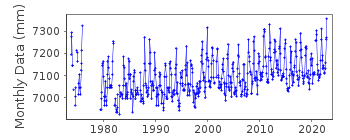
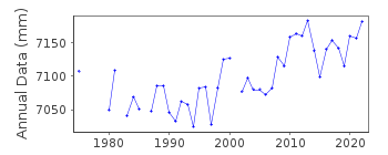
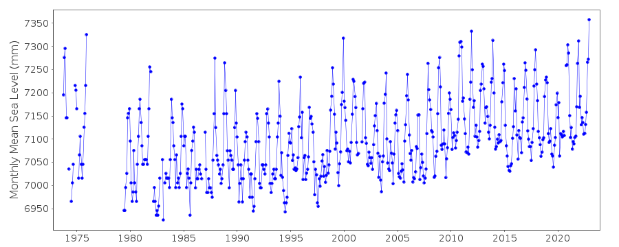
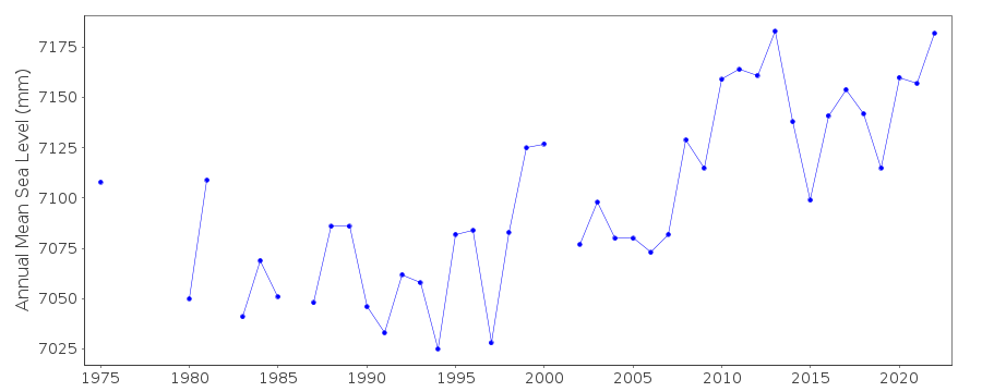
Station Information
| Station ID: | 1351 |
| Latitude: | 1.166667 |
| Longitude: | 103.75 |
| Coastline code: | 555 |
| Station code: | 11 |
| Country: | SINGAPORE |
| Time span of data: | 1973 – 2022 |
| Completeness (%): | 89 |
| Date of last update: | 24 Apr 2023 |
| Green Arrow: | Current Station |
| Yellow Marker: | Neighbouring RLR Station |
| Red Marker: | Neighbouring Metric Station |
Please note: In many cases, the station position in our database is accurate to only one minute. Thus, the tide gauge may not appear to be on the coast.
Tide Gauge Data
Station Documentation
Link to RLR information.Documentation added 1991-06-11
Raffles Lighthouse 555/011 RLR(1985) is 9.6m below Brass BoltDocumentation added 1994-07-12
Several apparent datum shifts in the record.Documentation added 2010-10-12
There are several changes of both the benchmark and the level of ACD throughout the Raffles dataset. Primary benchmark for 1973-1979 was Dampier Survey 'T' mark 4.260m above ACD. For 1979-1985 the benchmark was changed to the Brass Bolt 0.026 below the Dampier Survey 'T' mark .From 1986 onwards the ACD was defined as 4.175m below the Brass Bolt. During 2001 a new jetty was constructed the ACD remained the same but the Benchmark is now Cut Mark 4.300m above ACD - this remains the primary benchmark.Data Authority
Maritime Port Authority of SingaporeHydrographic Department
460 Alexandra Road, PSA Building
#20-00 Singapore 119963

![]()
![]()
![]()
