Data
- Obtaining
- Supplying
- High-Frequency
- Bottom Pressure Records
- Other Long Records
- GLOSS/ODINAFRICA Calibration Data
Donate
Donate to PSMSL
Data Notes
- Individual Station Data and Plot Notes
- Referencing the Data Set
- PSMSL Help File
- 2010 Changes to the PSMSL Data Files
Extracted from Database
11 Mar 2024
Station Information
| Station ID: | 1325 |
| Latitude: | 48.111667 |
| Longitude: | -122.756667 |
| Coastline code: | 823 |
| Station code: | 12 |
| Country: | UNITED STATES |
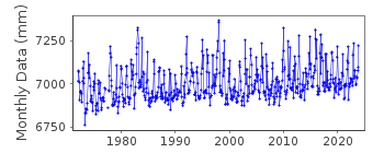
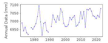
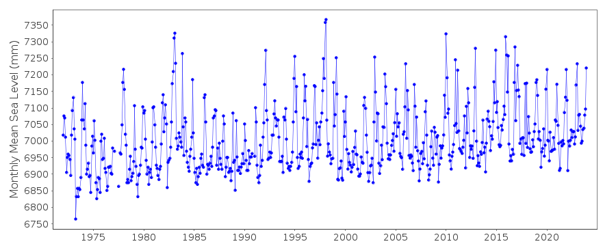
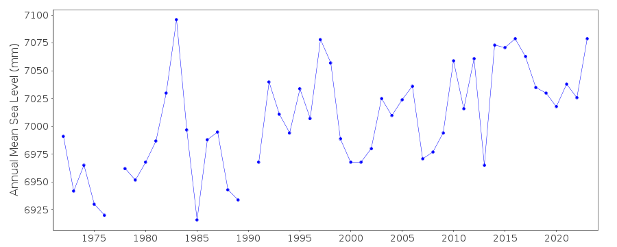
| Time span of data: | 1972 – 2023 |
| Completeness (%): | 99 |
| Date of last update: | 26 Jan 2024 |
| Green Arrow: | Current Station |
| Yellow Marker: | Neighbouring RLR Station |
| Red Marker: | Neighbouring Metric Station |
Please note: In many cases, the station position in our database is accurate to only one minute. Thus, the tide gauge may not appear to be on the coast.
Tide Gauge Data
Station Documentation
Link to RLR information.Documentation added 1991-06-11
Port Townsend 823/012 RLR(1974) is 9.0m below BM9Documentation added 2011-12-20
Using NOAA data the RLR diagram has been revised.Previous Primary benchmark BM 9 - NO 9 1952 still appears in the NOAA reports with a value of 4.541m in the 1988 report and 4.546m in the report of 2003. The value for benchmark NO 9 1952 on the original RLR diagram is 4.548m. Current Primary benchmark is TIDAL BM 18 1975 6.559m above gauge datum.Data Authority
N.O.A.A. / N.O.S.N/oes33, Ssmc4, Room 6531
1305 East-West Highway
Silver Spring,
MD 20910

![]()
![]()
![]()
