Data
- Obtaining
- Supplying
- High-Frequency
- Bottom Pressure Records
- Other Long Records
- GLOSS/ODINAFRICA Calibration Data
Donate
Donate to PSMSL
Data Notes
- Individual Station Data and Plot Notes
- Referencing the Data Set
- PSMSL Help File
- 2010 Changes to the PSMSL Data Files
Extracted from Database
11 Mar 2024
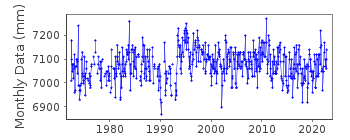
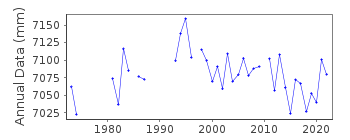
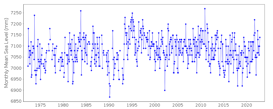
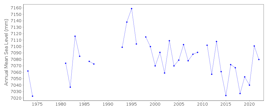
Station Information
| Station ID: | 1322 |
| Latitude: | 50.2 |
| Longitude: | -66.4 |
| Coastline code: | 970 |
| Station code: | 99 |
| Country: | CANADA |
| Time span of data: | 1972 – 2022 |
| Completeness (%): | 89 |
| Date of last update: | 16 Feb 2024 |
| Green Arrow: | Current Station |
| Yellow Marker: | Neighbouring RLR Station |
| Red Marker: | Neighbouring Metric Station |
Please note: In many cases, the station position in our database is accurate to only one minute. Thus, the tide gauge may not appear to be on the coast.
Tide Gauge Data
Station Documentation
Link to RLR information.Documentation added 1994-03-23
data up to 1992 revised, March 1994Documentation added 2011-09-06
Using data from the Fisheries and Oceans Canada the RLR diagram has beenupdated. Primary benchmark is now 80L307 5.651m above TGZ last inspected 2009.
Previously used benchmark 86L9267 9.471m above TGZ still exists but is now
registered as 9.489m above TGZ.
Documentation added 2015-07-27
This year, rather than just sending the latest year of data, the complete dataset has been supplied. This has highlighted some differences in the data. From communications in the correspondence file for 2002 it appears that the Oceans and Fisheries meant to supply revised data for the stations supplied. This did not happen. The complete dataset includes these data revisions. Therefore, the whole dataset has now been re-entered.Documentation added 2015-07-30
Historic data was included in the above complete dataset. The datum for the historic data is currently being queried. We await confirmation from the Fisheries and Oceans Canada.Data Authority
Canadian Hydrographic Service615 Booth Street
Ottawa
Ontario K1A 0E6

![]()
![]()
![]()
