Data
- Obtaining
- Supplying
- High-Frequency
- Bottom Pressure Records
- Other Long Records
- GLOSS/ODINAFRICA Calibration Data
Donate
Donate to PSMSL
Data Notes
- Individual Station Data and Plot Notes
- Referencing the Data Set
- PSMSL Help File
- 2010 Changes to the PSMSL Data Files
Extracted from Database
18 May 2026
WARNING: QCFLAG EXISTS. PLEASE READ THE DOCUMENTATION.
Station Information
| Station ID: | 131 |
| Latitude: | 38.296667 |
| Longitude: | 141.505278 |
| Coastline code: | 642 |
| Station code: | 31 |
| Country: | JAPAN |
| Time span of RLR data: | 1958 – 2025 |
| RLR completeness (%): | 93 |
| Time span of metric data: | 1900 – 2025 |
| Metric completeness (%): | 70 |
| Date of last update: | 08 Apr 2026 |
| Green Arrow: | Current Station |
| Yellow Marker: | Neighbouring RLR Station |
| Red Marker: | Neighbouring Metric Station |
Please note: In many cases, the station position in our database is accurate to only one minute. Thus, the tide gauge may not appear to be on the coast.
Tide Gauge Data
Station Documentation
Link to RLR information.Documentation added 1991-06-11
Ayukawa 642/031 RLR(1963) is 9.6m below Attached BMDocumentation added 2009-05-05
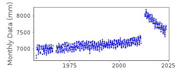
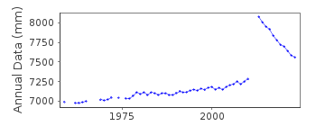
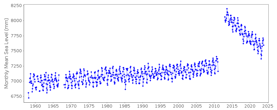
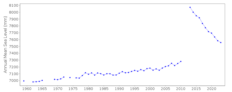
From the dataset plot there appears to be a rising trend at this station.Documentation added 2011-02-22
Profile buddy checks well with Ofunato II.Documentation added 2012-02-21
A massive earthquake magnitude 9.0 occurred at 14:46 JST (05:46 UTC) on Friday 11th March 2011 with the epicenter approx. 70 km east of the Oshika Peninsula of Tohoku. It was the most powerful known earthquake ever to have hit Japan. The earthquake triggered tsunami waves up to 40.5m travelling up to 10km inland. As is obvious from the data plot the tide gauge site was badly effected. The data following the tsunami is flagged.Documentation added 2022-04-05
Following review of data affected by the Tōhoku earthquake of 2011, all data has been flagged as good as GSI have recommenced levelling at the site. The station flag has been set to indicate the record needs to be treated with care, but the data appears to accurately reflect the earthquake's ongoing effect on local relative sea level.Data Authority
Japan Meteorological Agency3-6-9 Toranomon, Minato City
Tokyo

![]()
![]()
![]()
