Data
- Obtaining
- Supplying
- High-Frequency
- Bottom Pressure Records
- Other Long Records
- GLOSS/ODINAFRICA Calibration Data
Donate
Donate to PSMSL
Data Notes
- Individual Station Data and Plot Notes
- Referencing the Data Set
- PSMSL Help File
- 2010 Changes to the PSMSL Data Files
Extracted from Database
13 Oct 2025
Station Information
| Station ID: | 1302 |
| Latitude: | 13.583333 |
| Longitude: | -89.833333 |
| GLOSS ID: | 182 |
| Coastline code: | 833 |
| Station code: | 12 |
| Country: | EL SALVADOR |
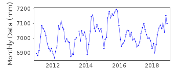
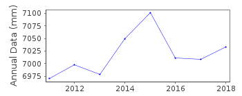
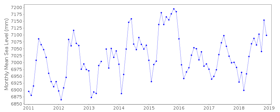
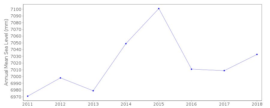
| Time span of RLR data: | 2011 – 2018 |
| RLR completeness (%): | 99 |
| Time span of metric data: | 1962 – 2018 |
| Metric completeness (%): | 88 |
| Date of last update: | 28 Jan 2020 |
| Green Arrow: | Current Station |
| Yellow Marker: | Neighbouring RLR Station |
| Red Marker: | Neighbouring Metric Station |
Please note: In many cases, the station position in our database is accurate to only one minute. Thus, the tide gauge may not appear to be on the coast.
Tide Gauge Data
Additional Data Sources (guide to additional data sources)
Nearby Real Time Stations from VLIZ: acajFast Delivery Data from UHSLC station 82: hourly and daily
Research Quality Data from UHSLC station 82: hourly and daily
Station Documentation
Link to RLR information.Documentation added 2001-03-22
Data for 1971-99 revised March 2001Documentation added 2013-10-14
3 UHSLC data files d082a.tsk 1962-07 to 2001-07, d082b.tsk 2001-08 to 2009-12, d082c.tsk 2010-08 to 2012-04 loaded. the original dataset for Acajutla 2 on the database was actually parts of the now overall data plot.Documentation added 2015-09-29
Using levelling information received from UHSLC Acajutla 2 has been made RLR from 2011. The levelling was referenced to the top of the tide staff which is 3.000m above the datum.Data Authority
University of Hawaii Sea Level CenterDepartment of Oceanography Division of Natural Sciences
1000 Pope Road
Honolulu
Hawaii 96822

![]()
![]()
![]()
