Data
- Obtaining
- Supplying
- High-Frequency
- Bottom Pressure Records
- Other Long Records
- GLOSS/ODINAFRICA Calibration Data
Donate
Donate to PSMSL
Data Notes
- Individual Station Data and Plot Notes
- Referencing the Data Set
- PSMSL Help File
- 2010 Changes to the PSMSL Data Files
Extracted from Database
08 Dec 2025
Station Information
| Station ID: | 1285 |
| Latitude: | 45.553333 |
| Longitude: | -123.918333 |
| Coastline code: | 823 |
| Station code: | 14 |
| Country: | UNITED STATES |
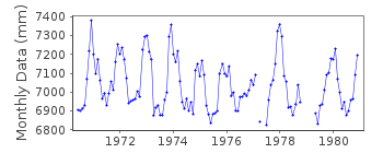
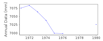
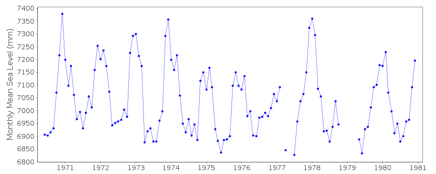
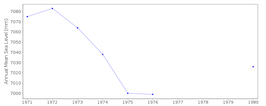
| Time span of data: | 1970 – 1980 |
| Completeness (%): | 89 |
| Date of last update: | 22 May 1987 |
| Green Arrow: | Current Station |
| Yellow Marker: | Neighbouring RLR Station |
| Red Marker: | Neighbouring Metric Station |
Please note: In many cases, the station position in our database is accurate to only one minute. Thus, the tide gauge may not appear to be on the coast.
Tide Gauge Data
Station Documentation
Link to RLR information.Documentation added 1991-06-11
Garibaldi 823/014 RLR(1974) is 10.0m below BM6Documentation added 2012-01-25
This is an historic station. Last data received is that for December 1980. Although Garibaldi appears in the NOAA Historic stations list the benchmark details are not the same. Therefore a copy of the original RLR diagram has been incoporated onto the web site. The station has been switched to 'inactive'.Data Authority
N.O.A.A. / N.O.S.N/oes33, Ssmc4, Room 6531
1305 East-West Highway
Silver Spring,
MD 20910

![]()
![]()
![]()
