Data
- Obtaining
- Supplying
- High-Frequency
- Bottom Pressure Records
- Other Long Records
- GLOSS/ODINAFRICA Calibration Data
Donate
Donate to PSMSL
Data Notes
- Individual Station Data and Plot Notes
- Referencing the Data Set
- PSMSL Help File
- 2010 Changes to the PSMSL Data Files
Extracted from Database
18 May 2026
Station Information
| Station ID: | 1268 |
| Latitude: | -10.60255 |
| Longitude: | 141.910133 |
| GLOSS ID: | 61 |
| Coastline code: | 680 |
| Station code: | 25 |
| Country: | AUSTRALIA |
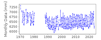
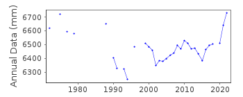
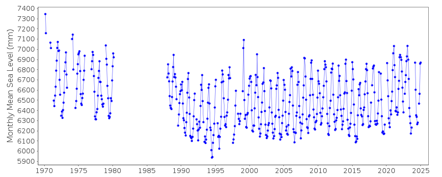
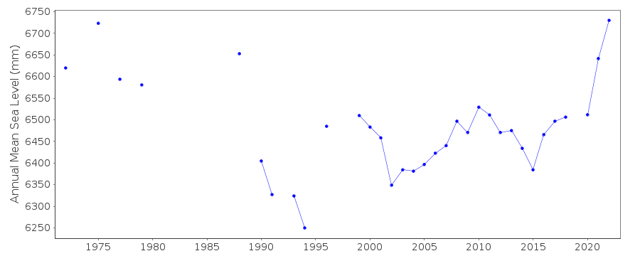
| Time span of data: | 1970 – 2025 |
| Completeness (%): | 74 |
| Date of last update: | 20 Mar 2025 |
| Green Arrow: | Current Station |
| Yellow Marker: | Neighbouring RLR Station |
| Red Marker: | Neighbouring Metric Station |
Please note: In many cases, the station position in our database is accurate to only one minute. Thus, the tide gauge may not appear to be on the coast.
Tide Gauge Data
Additional Data Sources (guide to additional data sources)
Fast Delivery Data from UHSLC station 336: hourly and dailyResearch Quality Data from UHSLC station 336: hourly and daily
Station Documentation
Link to RLR information.Documentation added 1995-05-02
Station density along some sections of the Australian coast has meant that station codes 601 onwards have been re-ordered compared to those in earlier versions of the PSMSL data set.Documentation added 1996-05-20
Revised data for 1970-91 received from the National Tidal Centre, South AustraliaDocumentation added 1998-01-23
Current type of gauge=float stilling well + pneumatic bubbler MACE electronic solid state recording system installed in May 1991Documentation added 2002-05-27
Booby Island 680/025 RLR(2000) is 14.7m below BM NMV/B/458Documentation added 2013-01-07
Site comprises a wooden hut on Booby Island and a concrete column. Gauge type is currently an Acoustic-in-air Aquatrak model 4100Documentation added 2021-02-03
As well as adding the data for 2020 data value for June 2019 has also been revised.Data Authority
National Tidal CentreBureau of Meteorology
PO Box 421
Kent Town 5071
South Australia
Documentation added 2010-08-12
Formerly known as the National Tidal Facility

![]()
![]()
![]()
