Data
- Obtaining
- Supplying
- High-Frequency
- Bottom Pressure Records
- Other Long Records
- GLOSS/ODINAFRICA Calibration Data
Donate
Donate to PSMSL
Data Notes
- Individual Station Data and Plot Notes
- Referencing the Data Set
- PSMSL Help File
- 2010 Changes to the PSMSL Data Files
Extracted from Database
24 Nov 2025
Station Information
| Station ID: | 1248 |
| Latitude: | 1.233333 |
| Longitude: | 103.65 |
| Coastline code: | 555 |
| Station code: | 21 |
| Country: | SINGAPORE |
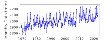
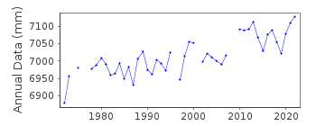
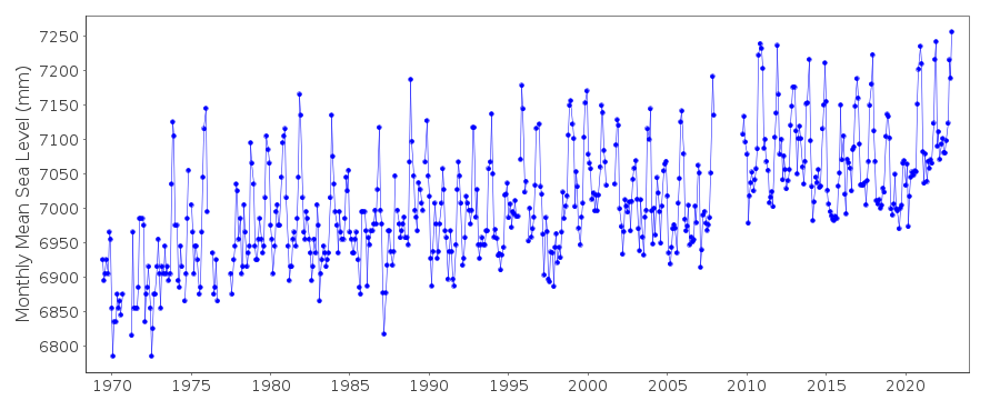
| Time span of data: | 1969 – 2022 |
| Completeness (%): | 91 |
| Date of last update: | 24 Apr 2023 |
| Green Arrow: | Current Station |
| Yellow Marker: | Neighbouring RLR Station |
| Red Marker: | Neighbouring Metric Station |
Please note: In many cases, the station position in our database is accurate to only one minute. Thus, the tide gauge may not appear to be on the coast.
Tide Gauge Data
Station Documentation
Link to RLR information.Documentation added 1991-06-11
Sultan Shoal 555/021 RLR(1986) is 10.2m below Brass BoltDocumentation added 1993-07-12
Sultan Shoal 555/021 RLR(1986) is 10.2m below Brass BoltDocumentation added 2010-10-12
Benchmark for the period 1969-1979 was Dampier Survey 'T' mark 6.500m aboveDatum 1969-1985. 1980-1985 benchmark was Brass Bolt 5.004m above Datum
1969-1985.
1986 onwards the ACD changed to 4.922m below the Brass Bolt. In 2009 a new
jetty was re-constructed ACD remained the same while Primary benchmark is now
Cut Mark 4.941m above ACD.
Because of the building of the new jetty there is a gap in the data Jan 2008-
Sept 2009.
Data Authority
Maritime Port Authority of SingaporeHydrographic Department
460 Alexandra Road, PSA Building
#20-00 Singapore 119963

![]()
![]()
![]()
