Data
- Obtaining
- Supplying
- High-Frequency
- Bottom Pressure Records
- Other Long Records
- GLOSS/ODINAFRICA Calibration Data
Donate
Donate to PSMSL
Data Notes
- Individual Station Data and Plot Notes
- Referencing the Data Set
- PSMSL Help File
- 2010 Changes to the PSMSL Data Files
Extracted from Database
02 Mar 2026
Station Information
| Station ID: | 111 |
| Latitude: | -32.055833 |
| Longitude: | 115.739444 |
| GLOSS ID: | 53 |
| Coastline code: | 680 |
| Station code: | 471 |
| Country: | AUSTRALIA |
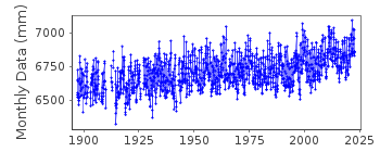
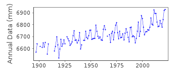
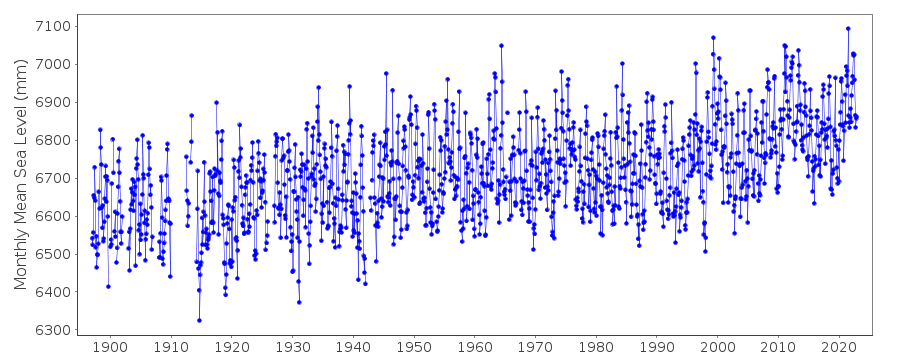
| Time span of data: | 1897 – 2022 |
| Completeness (%): | 93 |
| Date of last update: | 27 Feb 2023 |
| Green Arrow: | Current Station |
| Yellow Marker: | Neighbouring RLR Station |
| Red Marker: | Neighbouring Metric Station |
Please note: In many cases, the station position in our database is accurate to only one minute. Thus, the tide gauge may not appear to be on the coast.
Tide Gauge Data
Additional Data Sources (guide to additional data sources)
Fast Delivery Data from UHSLC station 175: hourly and dailyResearch Quality Data from UHSLC station 175: hourly and daily
Station Documentation
Link to RLR information.Documentation added 1995-05-02
Station density along some sections of the Australian coast has meant that station codes 601 onwards have been re-ordered compared to those in earlier versions of the PSMSL data set.Documentation added 2002-01-10
Gauge is a float gauge with shaft encoder and digital data logger. Hourly values are available from 1897.Documentation added 2002-01-10
Fremantle 680/471 RLR(1996) is 9.320m below BM NMV/F/6ADocumentation added 2012-07-04
On the RLR diagram for 2002 the Primary benchmark was NMV/F/6A3.32m above TGZ. Information for the updated RLR diagram was extracted from the National Tidal Centre of Australia website.Data Authority
National Tidal CentreBureau of Meteorology
PO Box 421
Kent Town 5071
South Australia
Documentation added 2010-08-12
Formerly known as the National Tidal Facility

![]()
![]()
![]()
