Data
- Obtaining
- Supplying
- High-Frequency
- Bottom Pressure Records
- Other Long Records
- GLOSS/ODINAFRICA Calibration Data
Donate
Donate to PSMSL
Data Notes
- Individual Station Data and Plot Notes
- Referencing the Data Set
- PSMSL Help File
- 2010 Changes to the PSMSL Data Files
Extracted from Database
06 Apr 2026
WARNING: QCFLAG EXISTS. PLEASE READ THE DOCUMENTATION.
Station Information
| Station ID: | 1067 |
| Latitude: | 61.238333 |
| Longitude: | -149.89 |
| Coastline code: | 821 |
| Station code: | 12 |
| Country: | UNITED STATES |
| Time span of data: | 1964 – 2025 |
| Completeness (%): | 87 |
| MTL Data: | 1964-1971 |
| MTL-MSL (mm): | -344 |
| Date of last update: | 09 Mar 2026 |
| Green Arrow: | Current Station |
| Yellow Marker: | Neighbouring RLR Station |
| Red Marker: | Neighbouring Metric Station |
Please note: In many cases, the station position in our database is accurate to only one minute. Thus, the tide gauge may not appear to be on the coast.
Tide Gauge Data
Additional Data Sources (guide to additional data sources)
Nearby GNSS Stations from SONEL: TSEA, TBON, ZAN1, PMKZ, ANC2Nearby Real Time Stations from VLIZ: anch2
Station Documentation
Link to RLR information.Documentation - date unknown
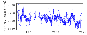
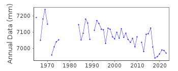
1964 - 1971 values based on readings of high and low waters.Documentation added 1992-04-02
South Alaskan coastline earthquake prone - e.g. magnitude 9.2 earthquake of 28th March 1964 - see Savage Plafker, JGR,96(B3), 4325-4335, 1991Documentation added 1993-07-12
Anchorage 821/012 RLR(1975) is 13.4m below BM15Documentation added 1994-07-12
Apparent datum shift around 1972-73.Documentation added 2011-06-23
May-December 2007 values replaced to bring PSMSL record in line with corrected data on NOAA website. Original reported high frequency water levels were between 0 and 22 cm higher than they actually were.Documentation added 2011-11-24
Using information from the NOAA website the RLR diagram has been revised. Primary benchmark previously called BM 15 13.237m relative to gauge datum corresponds with NOAA benchmark NO 15 RESET 1966. Value for this in both 1999 and 2003 reports is 13.231m.Documentation added 2016-01-22
A value of MTL-MSL=-344 mm has been applied to the RLR data for the period 1964-1971. This value was taken from the NOAA website for the station.Documentation added 2026-03-09
Updated revised data from June 2018 to November 2024. There was an error in the density correction value which caused as much as a 9cm error in the dataData Authority
N.O.A.A. / N.O.S.N/oes33, Ssmc4, Room 6531
1305 East-West Highway
Silver Spring,
MD 20910

![]()
![]()
![]()
