Data
- Obtaining
- Supplying
- High-Frequency
- Bottom Pressure Records
- Other Long Records
- GLOSS/ODINAFRICA Calibration Data
Donate
Donate to PSMSL
Data Notes
- Individual Station Data and Plot Notes
- Referencing the Data Set
- PSMSL Help File
- 2010 Changes to the PSMSL Data Files
Extracted from Database
13 Oct 2025
Station Information
| Station ID: | 1053 |
| Latitude: | 10.566667 |
| Longitude: | -62.283333 |
| Coastline code: | 900 |
| Station code: | 6 |
| Country: | VENEZUELA, BOLIVARIAN REPUBLIC OF |
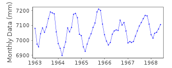
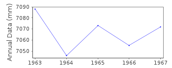
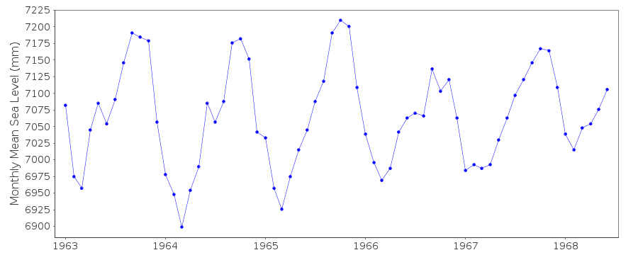
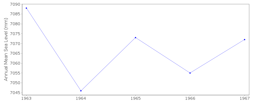
| Time span of data: | 1963 – 1968 |
| Completeness (%): | 92 |
| Date of last update: | 20 Apr 2001 |
| Green Arrow: | Current Station |
| Yellow Marker: | Neighbouring RLR Station |
| Red Marker: | Neighbouring Metric Station |
Please note: In many cases, the station position in our database is accurate to only one minute. Thus, the tide gauge may not appear to be on the coast.
Tide Gauge Data
Station Documentation
Link to RLR information.Documentation added 1991-06-11
Guiria 900/006 RLR(1964) is 14.3m below BM5Documentation added 1993-07-12
Guiria 900/006 RLR(1964) is 14.3m below BM5Guiria is an historic station last data 1968
Data Authority
Ministerio de Obras PublicasDireccion de Cartografia Nacional
Caracas

![]()
![]()
![]()
