Data
- Obtaining
- Supplying
- High-Frequency
- Bottom Pressure Records
- Other Long Records
- GLOSS/ODINAFRICA Calibration Data
Donate
Donate to PSMSL
Data Notes
- Individual Station Data and Plot Notes
- Referencing the Data Set
- PSMSL Help File
- 2010 Changes to the PSMSL Data Files
Extracted from Database
26 Jan 2026
Station Information
| Station ID: | 1049 |
| Latitude: | 5.616667 |
| Longitude: | 0 |
| Coastline code: | 410 |
| Station code: | 16 |
| Country: | GHANA |
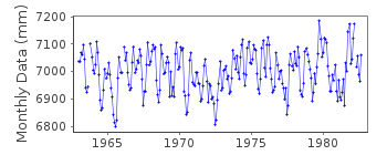
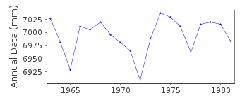
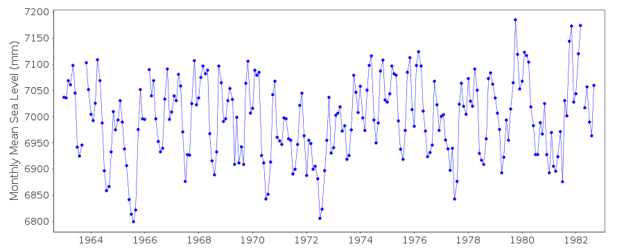
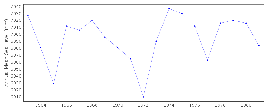
| Time span of data: | 1963 – 1982 |
| Completeness (%): | 98 |
| Date of last update: | 01 Jan 1980 |
| Green Arrow: | Current Station |
| Yellow Marker: | Neighbouring RLR Station |
| Red Marker: | Neighbouring Metric Station |
Please note: In many cases, the station position in our database is accurate to only one minute. Thus, the tide gauge may not appear to be on the coast.
Tide Gauge Data
Station Documentation
Link to RLR information.Documentation added 1991-06-11
Tema 410/016 RLR(1969) is 9.6m below BM PL8/5Documentation added 1993-07-12
Tema 410/016 RLR(1969) is 9.6m below BM PL8/5Documentation added 1995-11-01
replacement tide gauge installed in 1991: OTT type X(20.102)Documentation added 2002-02-06
(New) Tema gauge installed in 1991, but had operatingproblems and then the gauge was stolen.
Data Authority
Survey and Mapping DivisionP.O. Box CT 903
Cantonments
Accra

![]()
![]()
![]()
