Data
- Obtaining
- Supplying
- High-Frequency
- Bottom Pressure Records
- Other Long Records
- GLOSS/ODINAFRICA Calibration Data
Donate
Donate to PSMSL
Data Notes
- Individual Station Data and Plot Notes
- Referencing the Data Set
- PSMSL Help File
- 2010 Changes to the PSMSL Data Files
Extracted from Database
11 Mar 2024
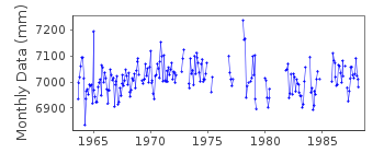
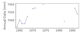
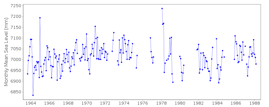
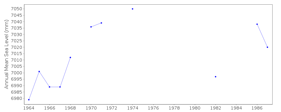
Station Information
| Station ID: | 1044 |
| Latitude: | 49.1 |
| Longitude: | -58.366667 |
| Coastline code: | 970 |
| Station code: | 106 |
| Country: | CANADA |
| Time span of data: | 1963 – 1988 |
| Completeness (%): | 67 |
| Date of last update: | 25 Oct 1993 |
| Green Arrow: | Current Station |
| Yellow Marker: | Neighbouring RLR Station |
| Red Marker: | Neighbouring Metric Station |
Please note: In many cases, the station position in our database is accurate to only one minute. Thus, the tide gauge may not appear to be on the coast.
Tide Gauge Data
Station Documentation
Link to RLR information.Documentation added 1994-03-23
data up to 1988 revised, March 1994Documentation added 1994-07-15
Lark Harbour 970/106 RLR(1974) is 9.1m below BM GSC 76F032Data Authority
Canadian Hydrographic Service615 Booth Street
Ottawa
Ontario K1A 0E6

![]()
![]()
![]()
