Data
- Obtaining
- Supplying
- High-Frequency
- Bottom Pressure Records
- Other Long Records
- GLOSS/ODINAFRICA Calibration Data
Donate
Donate to PSMSL
Data Notes
- Individual Station Data and Plot Notes
- Referencing the Data Set
- PSMSL Help File
- 2010 Changes to the PSMSL Data Files
Extracted from Database
02 Mar 2026
Station Information
| Station ID: | 103 |
| Latitude: | 40.433333 |
| Longitude: | 17.266667 |
| Coastline code: | 270 |
| Station code: | 6 |
| Country: | ITALY |
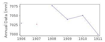
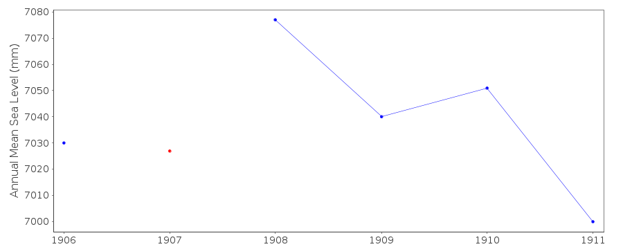
| Time span of RLR data: | 1906 – 1911 |
| RLR completeness (%): | 100 |
| Time span of metric data: | 1896 – 1966 |
| Metric completeness (%): | 12 |
| Date of last update: | 01 Jan 1980 |
| Green Arrow: | Current Station |
| Yellow Marker: | Neighbouring RLR Station |
| Red Marker: | Neighbouring Metric Station |
Please note: In many cases, the station position in our database is accurate to only one minute. Thus, the tide gauge may not appear to be on the coast.
Tide Gauge Data
Additional Data Sources (guide to additional data sources)
Nearby Real Time Stations from VLIZ: TA18, tara1Station Documentation
Link to RLR information.Documentation added 1991-06-11
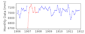
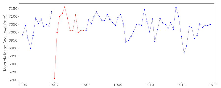
Taranto 270/006 RLR(1911) is 11.8m below BMDocumentation added 1993-07-30
Low value January 1907 - correct as received from authority.Taranto is an historic station. Last data 1911
Data Authority
Istituto Idrografico della MarinaPasso Osservatorio 4
16134 Genova

![]()
![]()
![]()
