Data
- Obtaining
- Supplying
- High-Frequency
- Bottom Pressure Records
- Other Long Records
- GLOSS/ODINAFRICA Calibration Data
Donate
Donate to PSMSL
Data Notes
- Individual Station Data and Plot Notes
- Referencing the Data Set
- PSMSL Help File
- 2010 Changes to the PSMSL Data Files
Extracted from Database
11 Mar 2024
Station Information
| Station ID: | 100 |
| Latitude: | 44.5 |
| Longitude: | 12.283333 |
| Coastline code: | 270 |
| Station code: | 35 |
| Country: | ITALY |
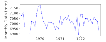
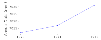
| Time span of RLR data: | 1969 – 1972 |
| RLR completeness (%): | 94 |
| Time span of metric data: | 1896 – 1972 |
| Metric completeness (%): | 74 |
| Date of last update: | 01 Jan 1980 |
| Green Arrow: | Current Station |
| Yellow Marker: | Neighbouring RLR Station |
| Red Marker: | Neighbouring Metric Station |
Please note: In many cases, the station position in our database is accurate to only one minute. Thus, the tide gauge may not appear to be on the coast.
Tide Gauge Data
Additional Data Sources (guide to additional data sources)
Nearby Real Time Stations from VLIZ: RA10Station Documentation
Link to RLR information.Documentation added 1991-06-11
Porto Corsini 270/035 RLR(1971) is 7.9m below BMDocumentation added 1994-07-14
For a discussion of submergence near to Porto Corsini see Emery and Aubrey (Sea Levels, Land Levels and Tide Gauges), 1991, Springer-Verlag, page 34.Porto Corsini is an historic station. Last data 1972
Documentation added 2020-11-20
Data 1969-1972 is based on Ferraro, S. (1972). Livelli marini adriatici e ionici rilevati alle stazioni mareografiche italiane. Atti Accad. Ligure Sc. Lett., XXIX, 3-18.Documentation added 2020-11-20
Data for 1896-1966 based on historic sources, details of which can be found in Bruni et al. (2019), J Geod 93, 1227-1244. https://doi.org/10.1007/s00190-019-01238-w. Data from that paper is published in ID 2361, which should be considered as superseding this recordData Authority
CNR - Istituto di Scienze MarineAREA Science Park
Basovizza
I-34149 Trieste
Documentation added 2008-10-31
This authority was formerly called the Istituto Talassograficodi Trieste.

![]()
![]()
![]()
