 Welcome to the World of Gravity
Welcome to the World of Gravity
Welcome to the World of Gravity
The purpose of this project is, with the aid of the absolute gravimeter, to measure the value of 'g' for a particular site, ie the acceleration towards the centre of the Earth caused by the gravitational field. The units used are metres per second per second.
Proudman Oceanographic Laboratory is measuring gravity as it is associated with mean sea level change. Sea level is measured using tide gauges which are fixed to the land. To know if the sea level is changing, one must know if the land is moving up or down, ie if there is any vertical crustal movement.
 The Absolute Gravimeter is designed to measure 'g' to an accuracy of 1 part
in 10e9. At this level, it is measuring to the nearest uGal,
ie 10e-6 gal where 1 gal = 1 cms**-2 .
The level of accuracy is necessary, particularly in areas with large vertical
uplift. For example, in Scotland the land is rising by as much as 3mm/year due
to isostatic adjustment from the last ice age. If the sea level is rising at
1mm/year, it would appear from Scotland that the sea level is falling. Only with
this handle on vertical crustal movement can the true sea level be monitored.
The Absolute Gravimeter is designed to measure 'g' to an accuracy of 1 part
in 10e9. At this level, it is measuring to the nearest uGal,
ie 10e-6 gal where 1 gal = 1 cms**-2 .
The level of accuracy is necessary, particularly in areas with large vertical
uplift. For example, in Scotland the land is rising by as much as 3mm/year due
to isostatic adjustment from the last ice age. If the sea level is rising at
1mm/year, it would appear from Scotland that the sea level is falling. Only with
this handle on vertical crustal movement can the true sea level be monitored.
                   Longitude   Latitude   Mean Gravity     Standard Error

1  Birkenhead      -03.072     53.400     Click for graph

2  Edinburgh       -03.177     55.924     9.81 579 188.5   0.73

3  Aberdeen        -02.101     57.170     9.81 688 363.3   1.08

4  Taunton         -03.075     51.022     9.81 168 835.0   1.16

5  Newlyn          -05.543     50.090     9.81 046 519.2   1.67

6  Herstmonceux     0.336      50.867     9.81 123 971.2   1.18

7  Lerwick         -1.340      60.150     9.81 944 006.9   1.57

8  Wick            -3.090      58.440     9.81 807 402.1   1.67
                   Longitude   Latitude   Mean Gravity     Standard Error

9  Paris
(site A1)          2.222       48.829     9.80 925 706.9   -
(site A)                                  9.80 925 716.7   -

10 Wettzell
North              12.880      49.145     9.81 835 256.0   0.68
South                                     9.81 835 250.8   0.86

11 Medicina        11.645      44.523     9.80 474 724.6   2.62
The values for g at this stage are preliminary, but will be accurate to within
10 microgals at a height of 130cm above the ground, at the measured point.
Absolute gravity observations, supported by accurate and localised relative gravity data can complement the GPS observations by providing an entirely independent measure of changes in the vertical and which are not reliant on satellite technology. In combination with GPS, which can only provide station coordinates and their change with time, the associated gravity change can provide a handle on the mechanisms of vertical change at TGBM's and thus allow some predictive capability.
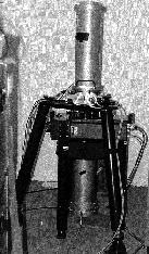
The principles of the measurement of absolute gravity are straightforward and were demonstrated by Galileo in his experiment which measured the Earth's acceleration due to gravity ('g') at Pisa, Italy hundreds of years ago. The latest free-fall absolute gravimeters employ the same physical principles and rely on the accurate measurement of the position and time of a test mass falling under the influence of the gravity field. The time standard is based on a Rubidium atomic clock and the length standard is defined by the wavelength of an iodine stabilised He-Ne laser.
Using the POL owned absolute gravimeter together with relative gravimeters from the University of Edinburgh, two new absolute gravity benchmarks have been established close to the tide gauges at Newlyn and Aberdeen and first epoch measurements have been made at these sites. The precision is better than 3 microgals (1 microgal = 10**-8 metres/sec**2). A change in the vertical displacement of as little as 1 cm can produce a detectable change in gravity of 2 microgals. These two sites were chosen as the first in this project as they have a number of advantages for establishing the technique. They both have long tide gauge records and are locations for a parallel programme of GPS measurements. Of more importance for the project is their local solid geology which should provide a solid foundation for the measurements.
The number of sites within the UK with absolute gravity measurements has recently increased to 9. The 'POL eight' are listed above; a ninth is at the National Physical Laboratory at Teddington using their own instrument. In 1996/97 three more sites were established.The first was at Herstmonceux in Sussex near to the RGO/NERC Satellite Laser Ranger (and only 20 km from the Newhaven tide gauge), the second at Wick, to extend the N-S profile, and the third at Lerwick, where the local vertical crustal movement is known to be significant. These new sites will provide new scientific challenges for the successful understanding of the observed gravity signal, in that for Herstmonceux careful measurements of the water table will be necessary and that the local ocean tide at Lerwick, an island site, will require careful modelling.
Of key importance to this work is the interconnection of all the absolute sites to the British Precise Gravity Network (BPGN) using relative gravimeters. This work together with the provision of gravity gradients and the protection of the absolute gravity values by the means of local "ex-centres" has been subcontracted to the Department of Geology and Geophysics at the University of Edinburgh. "Ex-centres" are sites in close proximity to the fundamental absolute gravity stations to which the gravity value has been transferred by means of relative gravity connections. In the event that a gravity benchmark is destroyed, then the value of gravity in the area should be recoverable.
The importance of water on the value of gravity has become apparent. Seasonal signals in the values of gravity obtained at POL suggest a strong correlation between the two. To investigate the affects of seasonal changes in groundwater level, boreholes were drilled on the sites at POL and Herstmonceaux. In relating absolute gravity and GPS measurements, analysis and modelling of groundwater behaviour near gravity sites has been shown to be important. Associated analyses at Edinburgh University on the British Precise Gravity Network (BPGN) suggest that the potential accuracy of the network may be as good as two microgals, which is equivalent to sub-centimetric precision.
For more information contact Dr. R.J. Edge at rje@pol.ac.uk