Data
- Obtaining
- Supplying
- High-Frequency
- Bottom Pressure Records
- Other Long Records
- GLOSS/ODINAFRICA Calibration Data
Donate
Donate to PSMSL
Data Notes
- Individual Station Data and Plot Notes
- Referencing the Data Set
- PSMSL Help File
- 2010 Changes to the PSMSL Data Files
Extracted from Database
13 Jul 2026
Station Information
| Station ID: | 998 |
| Latitude: | -44.39414 |
| Longitude: | 171.25613 |
| Coastline code: | 690 |
| Station code: | 26 |
| Country: | NEW ZEALAND |
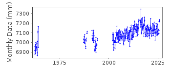
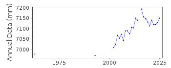
| Time span of data: | 1962 – 2025 |
| Completeness (%): | 46 |
| Date of last update: | 17 Feb 2026 |
| Green Arrow: | Current Station |
| Yellow Marker: | Neighbouring RLR Station |
| Red Marker: | Neighbouring Metric Station |
Please note: In many cases, the station position in our database is accurate to only one minute. Thus, the tide gauge may not appear to be on the coast.
Tide Gauge Data
Additional Data Sources (guide to additional data sources)
Research Quality Data from UHSLC station 665: hourly and dailyStation Documentation
Link to RLR information.Documentation added 1995-05-25
data prior to 1994 received from auth 53Documentation added 2003-01-17
New data from John Hannah added 17/01/03 which supercedes old data.New data does not have any missing days information.
Old data has been backed up.
Documentation added 2003-01-17
New data from John Hannah was for Auckland II, Dunedin II,Lyttelton II and Wellington II.
Documentation added 2005-10-17
There is a new John Hannah paper referring to New Zealand data forWellington, Dunedin, Lyttelton and Auckland. The reference is:
"An updated analysis of long-term sea level change in New Zealand."
Geophysical Research Letters, V31, L03307, doi:10.1029/2003GL019166
(2004).
Documentation added 2008-10-01
Revised data received from Glen Rowe at LINZdata span 1987-2007. Previous data for 1994 from
database copied data replaced with revised dataset.
Documentation added 2010-10-18
Following correspondence with Glen Rowe it was confirmed that the datum atTimaru has been as follows:
Pre 1976 TGZ =5.301m below benchmark UD 44
Post 1976 TGZ =5.286m below UD 44
Previous benchmark UD 42 is 0.466m above UD 44
Documentation added 2018-06-28
The Kaikoura earthquake of 23:02 on the 13 November 2016 impacted on a number of stations in the central part of New Zealand. Because of this the hourly height values for several stations from 14th November 00:00hrs have been adjusted by LINZ. For station Timaru the adjust is -0.008m.Documentation added 2020-08-25
The adjustment due to the Kaikōura earthquake of 2016 has been removed as relative sea level series should include land movement.Documentation added 2020-10-13
Benchmark UD44 has been destroyed, so UD42 is now the primary benchmark againDocumentation added 2021-08-23
A revised copy of the New Zealand data values for Timaru Harbour has been received from the data supplier the Land Information New Zealand (LINZ). The revised data begins from 2014. This exercise has been carried out to correct some anomalies with the high frequency data.Adjustment has also been applied to the data to account for the Kaikoura earthquake by creating a new datum TGZ December 2016 5.744m below benchmark UD42.
Consequently the Metric data has had the effect of Kaikoura removed but the effect of the earthquake is still evident in the RLR data.
Data Authority
Land Information New Zealand155 The Terrace
PO 5501
Wellington 6145

![]()
![]()
![]()
