Data
- Obtaining
- Supplying
- High-Frequency
- Bottom Pressure Records
- Other Long Records
- GLOSS/ODINAFRICA Calibration Data
Donate
Donate to PSMSL
Data Notes
- Individual Station Data and Plot Notes
- Referencing the Data Set
- PSMSL Help File
- 2010 Changes to the PSMSL Data Files
Extracted from Database
20 Jul 2026
Station Information
| Station ID: | 987 |
| Latitude: | 22.233333 |
| Longitude: | 114 |
| Coastline code: | 611 |
| Station code: | 8 |
| Country: | HONG KONG |
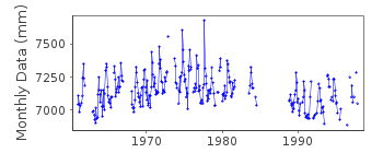
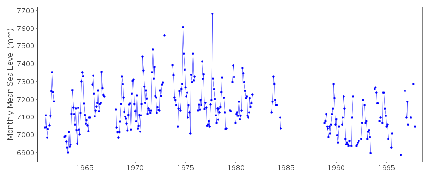
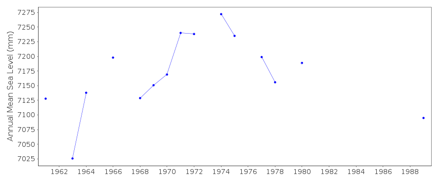
| Time span of data: | 1961 – 1997 |
| Completeness (%): | 63 |
| Date of last update: | 13 May 1998 |
| Green Arrow: | Current Station |
| Yellow Marker: | Neighbouring RLR Station |
| Red Marker: | Neighbouring Metric Station |
Please note: In many cases, the station position in our database is accurate to only one minute. Thus, the tide gauge may not appear to be on the coast.
Tide Gauge Data
Station Documentation
Link to RLR information.Documentation added 1991-06-11
Chi Ma Wan 611/008 RLR(1963) is 27.5m below BM at 4ADocumentation added 1993-07-12
Chi Ma Wan 611/008 RLR(1963) is 27.5m below BM at 4ADocumentation added 2002-01-09
For an analysis of sea level changes in Hong Kong, see"Sea level changes in Hong Kong from tide gauge measurements"
by X.Ding et al., Journal of Geodesy, 74, 683-689, 2001 and
"Long-term sea-level changes in Hong Kong from tide-gauge
records" by X.Ding et al., Journal of Coastal Research,
17, 749-754, 2001.
BEFORE 1986 DATA SUPPLIED BY AUTHORITY NO. 40
Documentation added 2012-10-09
This is now an historic station.Last data 1997.Data Authority
Hong Kong Observatory134A Nathan Road
Kowloon
Documentation added 2000-06-08
The Hong Kong Observatory was formerly known as the Royal Observatory.

![]()
![]()
![]()
