Data
- Obtaining
- Supplying
- High-Frequency
- Bottom Pressure Records
- Other Long Records
- GLOSS/ODINAFRICA Calibration Data
Donate
Donate to PSMSL
Data Notes
- Individual Station Data and Plot Notes
- Referencing the Data Set
- PSMSL Help File
- 2010 Changes to the PSMSL Data Files
Extracted from Database
13 Jul 2026
Station Information
| Station ID: | 986 |
| Latitude: | -25.966667 |
| Longitude: | 32.566667 |
| Coastline code: | 432 |
| Station code: | 1 |
| Country: | MOZAMBIQUE |
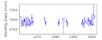
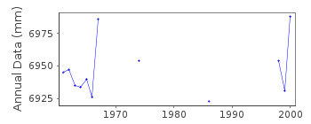
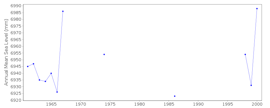
| Time span of data: | 1961 – 2001 |
| Completeness (%): | 40 |
| Date of last update: | 12 Oct 2005 |
| Green Arrow: | Current Station |
| Yellow Marker: | Neighbouring RLR Station |
| Red Marker: | Neighbouring Metric Station |
Please note: In many cases, the station position in our database is accurate to only one minute. Thus, the tide gauge may not appear to be on the coast.
Tide Gauge Data
Station Documentation
Link to RLR information.Documentation added 1991-06-11
Lourenco Marques 432/001 RLR(1967) is 10.9m below BM MN1Documentation added 1992-03-05
OLD NAME FOR MAPUTO WAS LOURENCO MARQUESDocumentation added 1993-07-12
Maputo 432/001 RLR(1967) is 10.9m below BM MN1Documentation added 1996-06-26
data for 1961-67 from auth 41Documentation added 1997-10-08
1961-1986 gauge type=R.Fuess; 1994 onwards gauge type=A.Ott R20Documentation added 1999-03-10
gauge is located in the fishing harbourDocumentation added 2002-04-25
Maputo - MN1 Benchmark destroyed 1999 during harbour works, and replacedby MN23 nearby. No direct relationship between the two as they didn't exist
at the same time. Continuance of same datum of observations assumed
to link the data together for RLR purposes.
Data 19th September 1999 onwards measured by Aanderaa equipment.
Maputo is now an historic station. Last data 2001.
Data Authority
Instituto Nacional de Hidrographia e NavegacaoAv. Karl Marx No. 153
Maputo

![]()
![]()
![]()
