Data
- Obtaining
- Supplying
- High-Frequency
- Bottom Pressure Records
- Other Long Records
- GLOSS/ODINAFRICA Calibration Data
Donate
Donate to PSMSL
Data Notes
- Individual Station Data and Plot Notes
- Referencing the Data Set
- PSMSL Help File
- 2010 Changes to the PSMSL Data Files
Extracted from Database
20 Jul 2026
Station Information
| Station ID: | 981 |
| Latitude: | 36.148256 |
| Longitude: | -5.3649 |
| GLOSS ID: | 248 |
| Coastline code: | 215 |
| Station code: | 1 |
| Country: | GIBRALTAR |
| Time span of data: | 1961 – 2014 |
| Completeness (%): | 67 |
| Date of last update: | 01 Sep 2014 |
| Green Arrow: | Current Station |
| Yellow Marker: | Neighbouring RLR Station |
| Red Marker: | Neighbouring Metric Station |
Please note: In many cases, the station position in our database is accurate to only one minute. Thus, the tide gauge may not appear to be on the coast.
Tide Gauge Data
Additional Data Sources (guide to additional data sources)
Nearby GNSS Stations from SONEL: GIBRNearby Real Time Stations from VLIZ: alge, gibr3, gibr2
Fast Delivery Data from UHSLC station 289: hourly and daily
Research Quality Data from UHSLC station 289: hourly and daily
Station Documentation
Link to RLR information.Documentation added 2000-05-10
Gibraltar 215/001 RLR(1964) is 9.7m below BM BoltAP TF 8812 0132Documentation added 2000-05-10
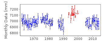
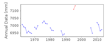
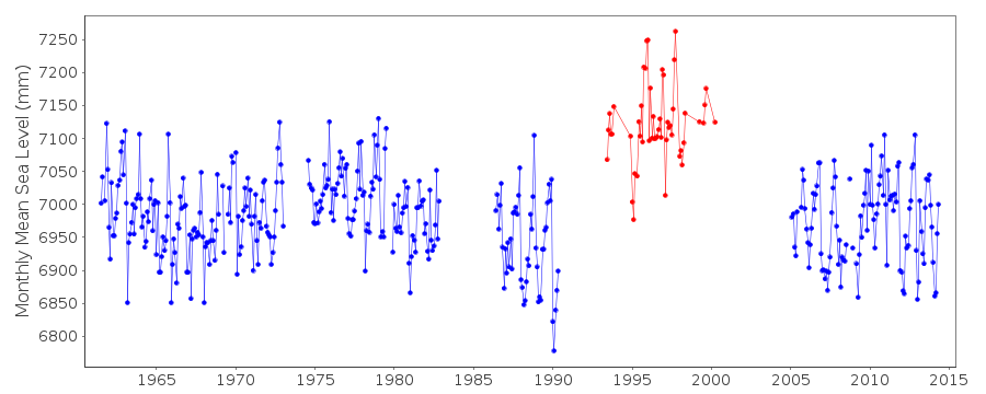
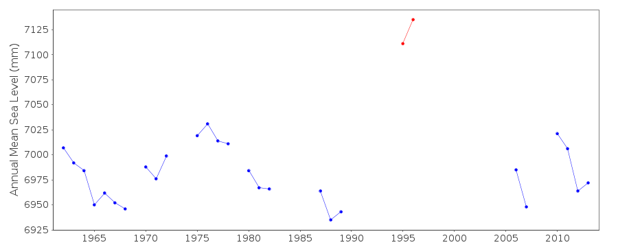
Large apparent datum shift after new gauge (Lea) installed in 1993.Documentation added 2001-10-15
Gibraltar - severe timing errors 1998-2000, plus many gaps. During 2005 a new OTT Kalesto radar gauge was installed in the commercial harbour to replace the previous float gauge in the naval harbour approximately 2km to the South (i.e. 36 deg 7'55"N 5 deg 21'21"W replaced 36 deg 8'54"N 5 deg 21'54"W). The replacement gauge was installed by the Tide Gauge Inspectorate of the Proudman Oceanographic Laboratory (POL). POL - now renamed the National Oceanography Centre (NOC) remained the supplying authority.Documentation added 2009-05-27
From the beginning of February 2009 data for Gibraltar transmitted via satellite to Ostend rather than being obtained via landline.Documentation added 2014-09-08
As individual data points for the period June 1993-April 2000 have been flagged it was decided to remove the station flag.Data Authority
British Oceanographic Data CentreNational Oceanography Centre
Joseph Proudman Building, 6 Brownlow Street
Liverpool
L3 5DA

![]()
![]()
![]()
