Data
- Obtaining
- Supplying
- High-Frequency
- Bottom Pressure Records
- Other Long Records
- GLOSS/ODINAFRICA Calibration Data
Donate
Donate to PSMSL
Data Notes
- Individual Station Data and Plot Notes
- Referencing the Data Set
- PSMSL Help File
- 2010 Changes to the PSMSL Data Files
Extracted from Database
13 Jul 2026
Station Information
| Station ID: | 958 |
| Latitude: | 43.397598 |
| Longitude: | 3.69911 |
| Coastline code: | 230 |
| Station code: | 21 |
| Country: | FRANCE |
| Time span of RLR data: | 1992 – 2025 |
| RLR completeness (%): | 87 |
| Time span of metric data: | 1960 – 2025 |
| Metric completeness (%): | 50 |
| Date of last update: | 20 Feb 2026 |
| Green Arrow: | Current Station |
| Yellow Marker: | Neighbouring RLR Station |
| Red Marker: | Neighbouring Metric Station |
Please note: In many cases, the station position in our database is accurate to only one minute. Thus, the tide gauge may not appear to be on the coast.
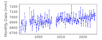
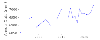
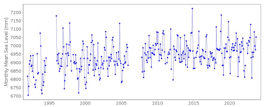
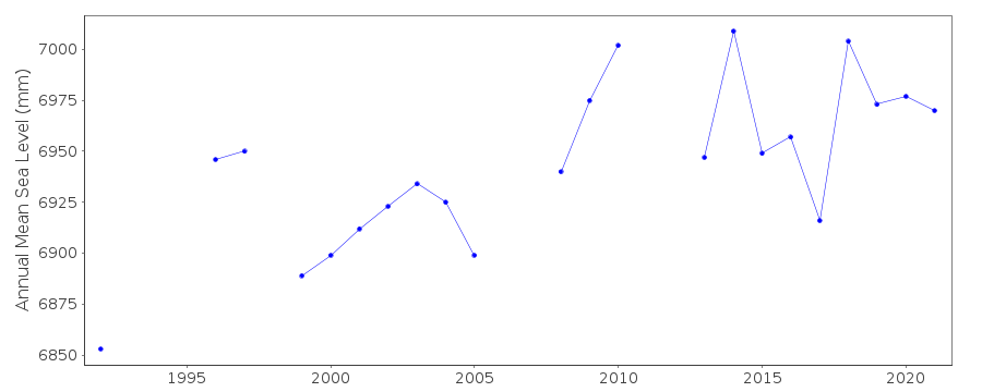
Tide Gauge Data
Additional Data Sources (guide to additional data sources)
Nearby GNSS Stations from SONEL: SETENearby Real Time Stations from VLIZ: sete, sete2
Station Documentation
Link to RLR information.Documentation added 2000-10-17
Data now supplied by Service Hydrographique et Ocean. de la Marine, Brest.Documentation added 2000-10-19
Sete RLR(2000) is 8.775m below BM MC-J3-K3-46.Documentation added 2012-04-04
Previous primary benchmark MC-J3-K3-46 was destroyed in 2004. New Primary benchmark is M.EM3-39 6.422m above Zero Hydrographique and 6.125m above IGN 69.Documentation added 2014-10-02
Using data from SONEL the latitude and longitude for Sete has been updated. The data downloaded from SONEL contained many additional data points particularly for the 1990's. Because of this the whole dataset has been reloaded onto the database.Documentation added 2016-06-22
While entering the 2015 data to the dataset it was noted that data points for November-December 2011 had been revised.Documentation added 2025-07-15
Updated the whole dataset to ensure they include all the historical data recovered recently by SHOM and the calculated monthly and annual means match those distributed by SONEL.Data Authority
SHOM13 rue de Chatelier
29200 BREST

![]()
![]()
![]()
