Data
- Obtaining
- Supplying
- High-Frequency
- Bottom Pressure Records
- Other Long Records
- GLOSS/ODINAFRICA Calibration Data
Donate
Donate to PSMSL
Data Notes
- Individual Station Data and Plot Notes
- Referencing the Data Set
- PSMSL Help File
- 2010 Changes to the PSMSL Data Files
Extracted from Database
13 Jul 2026
Station Information
| Station ID: | 956 |
| Latitude: | 37.451944 |
| Longitude: | 126.592222 |
| Coastline code: | 620 |
| Station code: | 11 |
| Country: | KOREA, REPUBLIC OF |
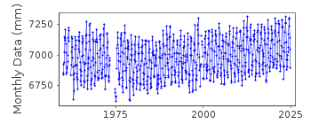
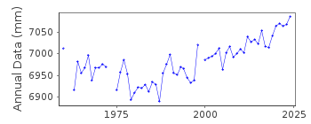
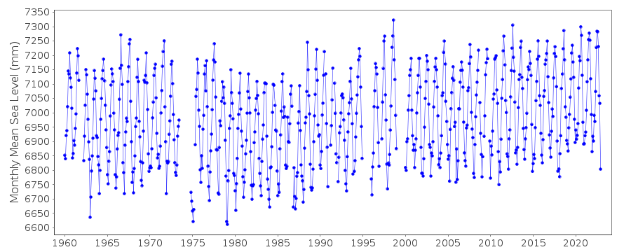
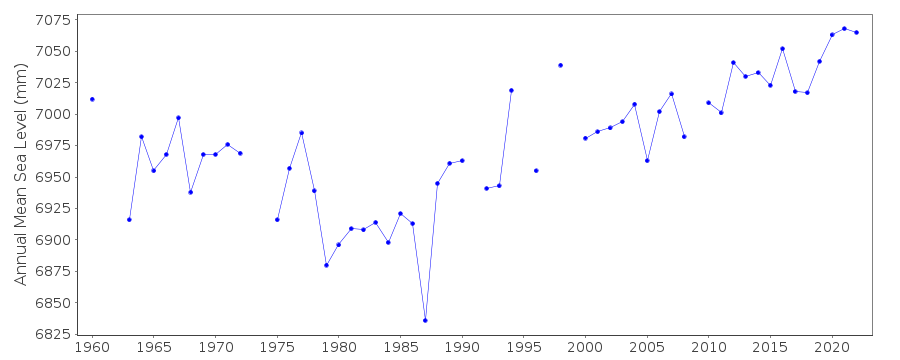
| Time span of RLR data: | 1960 – 2024 |
| RLR completeness (%): | 97 |
| Time span of metric data: | 1960 – 2024 |
| Metric completeness (%): | 97 |
| Date of last update: | 10 Apr 2026 |
| Green Arrow: | Current Station |
| Yellow Marker: | Neighbouring RLR Station |
| Red Marker: | Neighbouring Metric Station |
Please note: In many cases, the station position in our database is accurate to only one minute. Thus, the tide gauge may not appear to be on the coast.
Tide Gauge Data
Station Documentation
Link to RLR information.Documentation added 1991-06-11
Inchon 620/011 RLR(1964) is 12.5m below BM(origin point)Documentation added 1993-02-26
gauge resited 1974Documentation added 2001-01-30
Inchon - new gauge 1998/99, no further information as yet.Documentation added 2012-07-30
At the request of the data suppliers, KHOA the name of the station has beenrevised to Incheon. The values for lat. and long. have also been revised.
Tide gauge is an OTT float
Documentation added 2026-04-16
Updated the entire dataset to L2 dataset to ensure users can access fully quality-controlled sea level data for long-term variability and trend analysis.Data Authority
Korea Hydrographic and Oceanographic Agency (KHOA)351, Haeyang-ro
Yeongdo-gu
Busan
Republic of Korea
Documentation added 2000-10-11
The National Oceanographic Research Institute of Korea wasformerly (pre late-1990s) the Office of Hydrographic Affairs
(same address).
Documentation added 2018-05-17
KHOA was formerly the National Oceanographic Research Institute

![]()
![]()
![]()
