Data
- Obtaining
- Supplying
- High-Frequency
- Bottom Pressure Records
- Other Long Records
- GLOSS/ODINAFRICA Calibration Data
Donate
Donate to PSMSL
Data Notes
- Individual Station Data and Plot Notes
- Referencing the Data Set
- PSMSL Help File
- 2010 Changes to the PSMSL Data Files
Extracted from Database
22 Jun 2026
Station Information
| Station ID: | 939 |
| Latitude: | 52.013222 |
| Longitude: | -4.98375 |
| Coastline code: | 170 |
| Station code: | 183 |
| Country: | UNITED KINGDOM |
| Time span of RLR data: | 1974 – 1986 |
| RLR completeness (%): | 93 |
| Time span of metric data: | 1959 – 1987 |
| Metric completeness (%): | 88 |
| Date of last update: | 18 Mar 1991 |
| Green Arrow: | Current Station |
| Yellow Marker: | Neighbouring RLR Station |
| Red Marker: | Neighbouring Metric Station |
Please note: In many cases, the station position in our database is accurate to only one minute. Thus, the tide gauge may not appear to be on the coast.
Tide Gauge Data
Additional Data Sources (guide to additional data sources)
Nearby Real Time Stations from VLIZ: fishStation Documentation
Link to RLR information.Documentation added 1991-06-11
Fishguard I 170/183 RLR(1982) is 12.3m below BM SM9513 3874Documentation added 1992-07-14
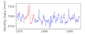
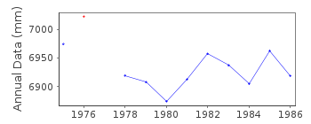
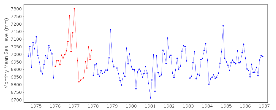
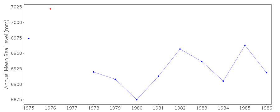
AUGUST 1976-SEPTEMBER 1977: GAUGE FAULTS RESULTED IN RANDOM DATUM ERRORS- TREAT WITH CAUTION
Documentation added 1993-07-12
Fishguard I 170/183 RLR(1982) is 12.3m below BM SM9513 3874Documentation added 1994-07-20
A Lea stilling well gauge was installed in 1958, moved to a newsite sometime before October 1975 (date uncertain).
Fishguard (170/183) was replaced by Fishguard II (170/184).
Fishguard is an historic station last data 1986 see above comment.
Documentation added 2001-01-02
Recent work on vertical land movements in the UK can be found fromthe University of Nottingham web site:
http://ukcogr.iessg.nottingham.ac.uk/~eosi/
PRIOR TO 1963 VALUES BASED ON 8 READINGS/DAY.
STABILITY IN DOUBT UNTIL AT LEAST 1972 AND RELIABILITY IN QUESTION UNTIL
REMOVAL IN 1988
Data Authority
British Oceanographic Data CentreNational Oceanography Centre
Joseph Proudman Building, 6 Brownlow Street
Liverpool
L3 5DA

![]()
![]()
![]()
