Data
- Obtaining
- Supplying
- High-Frequency
- Bottom Pressure Records
- Other Long Records
- GLOSS/ODINAFRICA Calibration Data
Donate
Donate to PSMSL
Data Notes
- Individual Station Data and Plot Notes
- Referencing the Data Set
- PSMSL Help File
- 2010 Changes to the PSMSL Data Files
Extracted from Database
20 Jul 2026
Station Information
| Station ID: | 926 |
| Latitude: | -13.4 |
| Longitude: | 48.283333 |
| GLOSS ID: | 15 |
| Coastline code: | 440 |
| Station code: | 1 |
| Country: | MADAGASCAR |
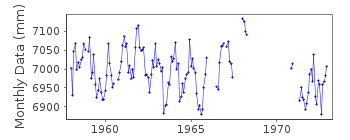
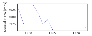
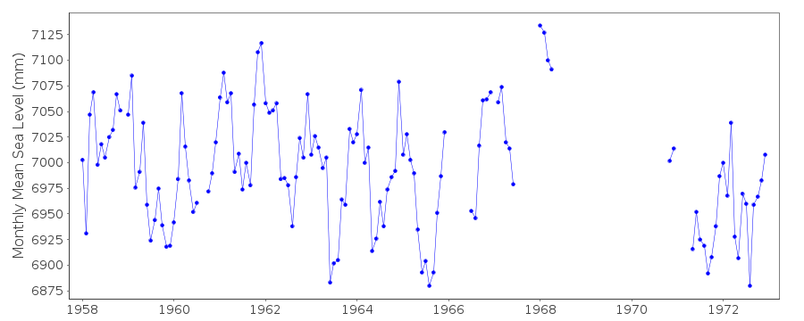
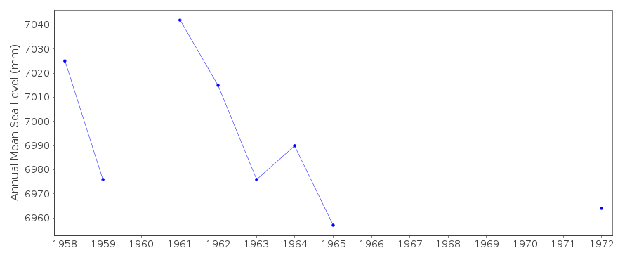
| Time span of data: | 1958 – 1972 |
| Completeness (%): | 72 |
| Date of last update: | 01 Jan 1980 |
| Green Arrow: | Current Station |
| Yellow Marker: | Neighbouring RLR Station |
| Red Marker: | Neighbouring Metric Station |
Please note: In many cases, the station position in our database is accurate to only one minute. Thus, the tide gauge may not appear to be on the coast.
Tide Gauge Data
Additional Data Sources (guide to additional data sources)
Research Quality Data from UHSLC station 150: hourly and dailyStation Documentation
Link to RLR information.Documentation added 1991-06-11
Nosy-Be 440/001 RLR(1972) is 12.5m below Repere A1(1964)Data Authority
SHOM13 rue de Chatelier
29200 BREST

![]()
![]()
![]()
