Data
- Obtaining
- Supplying
- High-Frequency
- Bottom Pressure Records
- Other Long Records
- GLOSS/ODINAFRICA Calibration Data
Donate
Donate to PSMSL
Data Notes
- Individual Station Data and Plot Notes
- Referencing the Data Set
- PSMSL Help File
- 2010 Changes to the PSMSL Data Files
Extracted from Database
20 Jul 2026
Station Information
| Station ID: | 916 |
| Latitude: | 55.366667 |
| Longitude: | -7.333333 |
| GLOSS ID: | 239 |
| Coastline code: | 175 |
| Station code: | 11 |
| Country: | IRELAND |
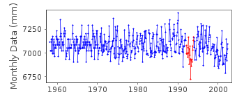
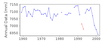
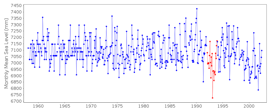
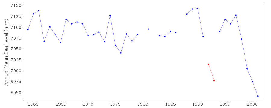
| Time span of data: | 1958 – 2002 |
| Completeness (%): | 95 |
| Date of last update: | 15 Jan 2004 |
| Green Arrow: | Current Station |
| Yellow Marker: | Neighbouring RLR Station |
| Red Marker: | Neighbouring Metric Station |
Please note: In many cases, the station position in our database is accurate to only one minute. Thus, the tide gauge may not appear to be on the coast.
Tide Gauge Data
Additional Data Sources (guide to additional data sources)
Nearby GNSS Stations from SONEL: MLHDNearby Real Time Stations from VLIZ: malh
Fast Delivery Data from UHSLC station 834: hourly and daily
Research Quality Data from UHSLC station 834: hourly and daily
Station Documentation
Link to RLR information.Documentation added 1992-04-29
New gauge 1/1/91 (OTT HBE 20.501)Documentation added 1992-09-23
1958-71 fcode=24Documentation added 1993-07-12
Malin Head 175/011 RLR(1976) is 30.4m below FBMDocumentation added 1995-09-29
Calibration check carried out on 31st August 1993 showed that the readings were 6cm low but it is not possible to say when the error occurred.Data Authority
Hydrometric SectionOPW
Headford
Co. Galway

![]()
![]()
![]()
