Data
- Obtaining
- Supplying
- High-Frequency
- Bottom Pressure Records
- Other Long Records
- GLOSS/ODINAFRICA Calibration Data
Donate
Donate to PSMSL
Data Notes
- Individual Station Data and Plot Notes
- Referencing the Data Set
- PSMSL Help File
- 2010 Changes to the PSMSL Data Files
Extracted from Database
13 Jul 2026
Station Information
| Station ID: | 9 |
| Latitude: | 51.9175 |
| Longitude: | 4.249722 |
| Coastline code: | 150 |
| Station code: | 61 |
| Country: | NETHERLANDS, KINGDOM OF THE |
| Time span of data: | 1848 – 2025 |
| Completeness (%): | 100 |
| Date of last update: | 01 Jul 2026 |
| Green Arrow: | Current Station |
| Yellow Marker: | Neighbouring RLR Station |
| Red Marker: | Neighbouring Metric Station |
Please note: In many cases, the station position in our database is accurate to only one minute. Thus, the tide gauge may not appear to be on the coast.
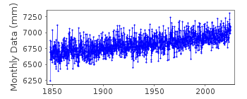
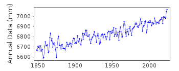
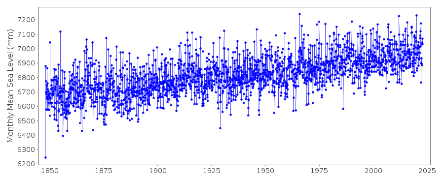
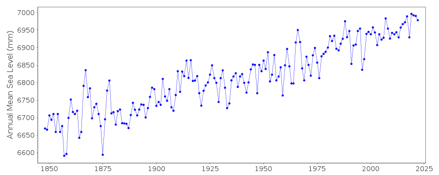
Tide Gauge Data
Additional Data Sources (guide to additional data sources)
Nearby GNSS Stations from SONEL: DLF1, DLFTStation Documentation
Link to RLR information.Documentation - date unknown
ALL DUTCH METRIC DATA ARE MEASURED TO NAP (NORMAAL AMSTERDAMSCH PEIL)PRIOR TO 1936 VALUES BASED ON HIGH AND LOW WATERS OR ON 4 OR 8 READINGS/DAY
Documentation added 2011-02-10
From information received regarding the values of NAP pre. and post the re-levelling of 2005 the station has now been made RLR. RLR factor pre.2005 6.775m 2005 onwards 6.799m.Documentation added 2016-01-22
The note above stating periods of the data are MTL is misleading. Sections of the original data were MTL. However, Pub. Sci. 5 states “For these periods a shallow water correction has been added to the mean heights of high and low water in order to give a mean height of sea-level comparable with those otherwise calculated for other periods.” Thus, a correction to MSL has already been applied.Data Authority
Servicedesk DataRijkswaterstaat
Postbus 556
3000 AN Rotterdam

![]()
![]()
![]()
