Data
- Obtaining
- Supplying
- High-Frequency
- Bottom Pressure Records
- Other Long Records
- GLOSS/ODINAFRICA Calibration Data
Donate
Donate to PSMSL
Data Notes
- Individual Station Data and Plot Notes
- Referencing the Data Set
- PSMSL Help File
- 2010 Changes to the PSMSL Data Files
Extracted from Database
13 Jul 2026
Station Information
| Station ID: | 811 |
| Latitude: | 35.547778 |
| Longitude: | 133.243056 |
| Coastline code: | 647 |
| Station code: | 41 |
| Country: | JAPAN |
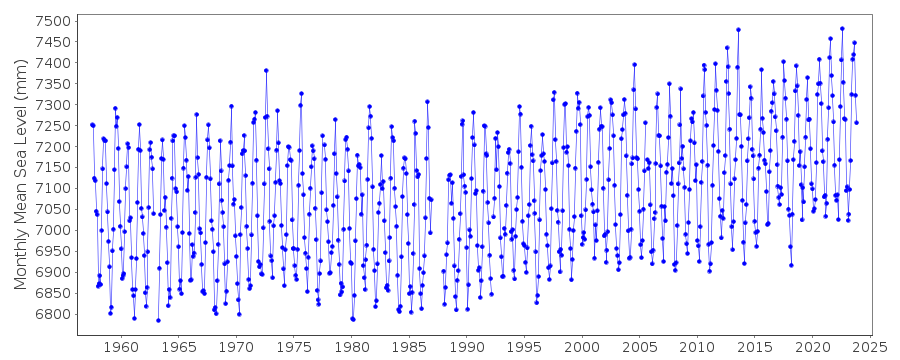
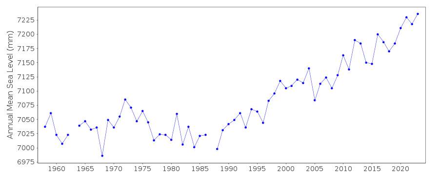
| Time span of data: | 1957 – 2025 |
| Completeness (%): | 97 |
| Date of last update: | 01 Apr 2026 |
| Green Arrow: | Current Station |
| Yellow Marker: | Neighbouring RLR Station |
| Red Marker: | Neighbouring Metric Station |
Please note: In many cases, the station position in our database is accurate to only one minute. Thus, the tide gauge may not appear to be on the coast.
Tide Gauge Data
Station Documentation
Link to RLR information.Documentation added 1991-06-11
Sakai 647/041 RLR(1966) is 8.0m below Attached BMDocumentation added 2002-03-26
Sakai gauge replaced May 1978.Documentation added 2003-11-20
Datum 1997 is 1.200m below Tokyo Peil.Documentation added 2011-02-23
Dataset buddy checked with Saigo - Saigo profile is generally lower but features compare well.Documentation added 2012-02-21
A massive earthquake magnitude 9.0 occurred at 14.46 JST (05.46 UTC) on Friday 11th March 2011 with the epicentre 70km east of the Oshika Peninsula of Tohoku.It was the most powerful known earthquake to hit Japan triggering a tsunami with waves up to 40.5m and travelling up to 10km inland.Data Authority
Japan Meteorological Agency3-6-9 Toranomon, Minato City
Tokyo

![]()
![]()
![]()
