Data
- Obtaining
- Supplying
- High-Frequency
- Bottom Pressure Records
- Other Long Records
- GLOSS/ODINAFRICA Calibration Data
Donate
Donate to PSMSL
Data Notes
- Individual Station Data and Plot Notes
- Referencing the Data Set
- PSMSL Help File
- 2010 Changes to the PSMSL Data Files
Extracted from Database
13 Jul 2026
Station Information
| Station ID: | 802 |
| Latitude: | 55.983333 |
| Longitude: | -3.166667 |
| Coastline code: | 170 |
| Station code: | 31 |
| Country: | UNITED KINGDOM |
| Time span of data: | 1956 – 1971 |
| Completeness (%): | 81 |
| Date of last update: | 04 Aug 1989 |
| Green Arrow: | Current Station |
| Yellow Marker: | Neighbouring RLR Station |
| Red Marker: | Neighbouring Metric Station |
Please note: In many cases, the station position in our database is accurate to only one minute. Thus, the tide gauge may not appear to be on the coast.
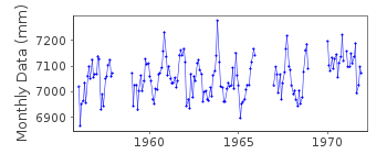
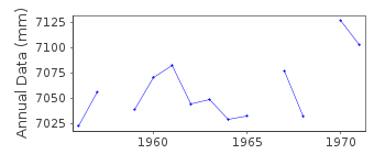
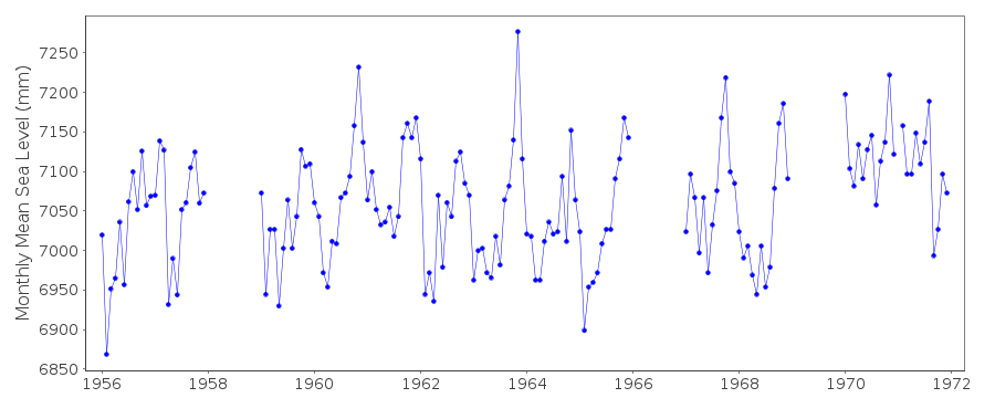
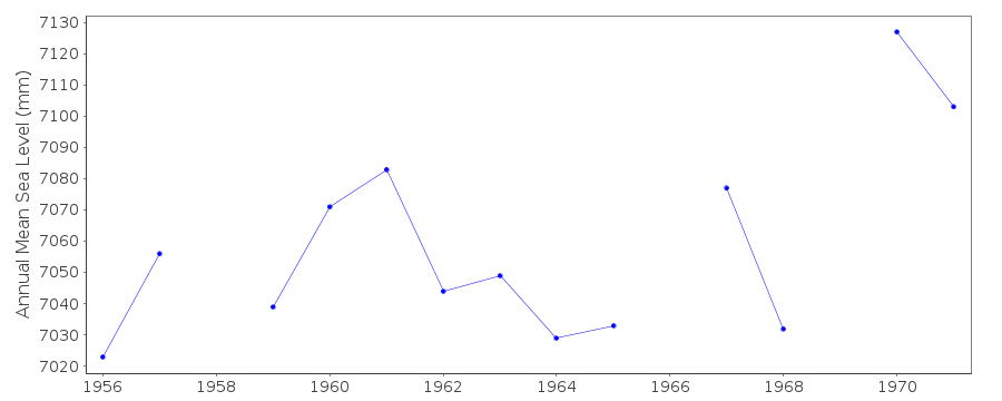
Tide Gauge Data
Additional Data Sources (guide to additional data sources)
Nearby GNSS Stations from SONEL: EDINNearby Real Time Stations from VLIZ: leit
Station Documentation
Link to RLR information.Documentation added 1991-06-11
Leith 170/031 RLR(1965) is 11.7m below BM NT27l6 7670Documentation added 1994-07-21
Gauge employed at Leith were as follows. Data exist from an unknown gauge type in 1949. In January 1954 a Lege stilling well gauge was installed. Harbour works and siltation are reported from 1966 onwards. The Lege was moved to a new site in October 1966 and remained until March 1969. It was moved to another new site in December 1969. A Munro gauge was installed in August 1979 and an Ott in 1980. Since December 1988 data have been taken from a POL-designed potentiometer system attached to the stilling well.Documentation added 1994-09-16
Ott gauge installed in 1980 was in use until May 1981 1966 and 1969 data unreliable - omitted. Leith is an historic station last data 1971. Gauge was replaced by Leith II id. 1526 as benchmark connection was not possible.Documentation added 2001-01-02
Recent work on vertical land movements in the UK can be found from the University of Nottingham web site: http://ukcogr.iessg.nottingham.ac.uk/~eosi/ for 1961-62 values based on 8 readings per day. For 1982 onwards values based on 24 readings per day.Data Authority
British Oceanographic Data CentreNational Oceanography Centre
Joseph Proudman Building, 6 Brownlow Street
Liverpool
L3 5DA

![]()
![]()
![]()
