Data
- Obtaining
- Supplying
- High-Frequency
- Bottom Pressure Records
- Other Long Records
- GLOSS/ODINAFRICA Calibration Data
Donate
Donate to PSMSL
Data Notes
- Individual Station Data and Plot Notes
- Referencing the Data Set
- PSMSL Help File
- 2010 Changes to the PSMSL Data Files
Extracted from Database
13 Jul 2026
Station Information
| Station ID: | 789 |
| Latitude: | 54.372222 |
| Longitude: | 10.156944 |
| Coastline code: | 125 |
| Station code: | 21 |
| Country: | GERMANY |
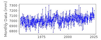
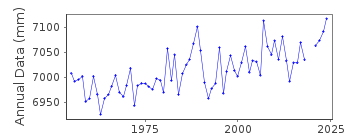
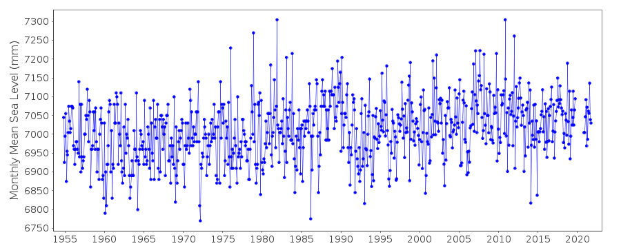
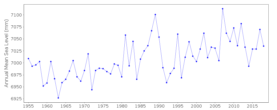
| Time span of data: | 1954 – 2025 |
| Completeness (%): | 97 |
| Link to ellipsoid: | Available |
| Date of last update: | 07 Nov 2025 |
| Green Arrow: | Current Station |
| Yellow Marker: | Neighbouring RLR Station |
| Red Marker: | Neighbouring Metric Station |
Please note: In many cases, the station position in our database is accurate to only one minute. Thus, the tide gauge may not appear to be on the coast.
Tide Gauge Data
Additional Data Sources (guide to additional data sources)
Nearby GNSS Stations from SONEL: HOLT, HOL2Station Documentation
Link to RLR information.Documentation added 2002-01-23
Kiel data up to 1992 supplied by Wasser und Schiffahrts. Nord, Kiel (auth=13). Data 1993- supplied by Bundesamt fur Seeschiffahrt und Hydrographie (BSH), Hamburg (auth=16).Documentation added 2010-08-09
The data for Kiel-Holtenau was measured to PN = NN-500cm Normal depth of PN=500cm. Normal Null(NN)is a German datum related to levels at Potsdam near Berlin. It is similar to ODN in the UK and the NAP in Holland. It is unusual therefore that the German stations have been made RLR as it 'breaks the rules' of RLR. Data now refers to TGZ.Documentation added 2013-01-22
Value for PHP relative to NHN is 4.995m from 12.04.2006. See letter of 21 November 2012.Data Authority
Bundesamt fur Seeschifffahrt und Hydrographie HamburgBernhard-Nocht-Strasse 78
20359 Hamburg
Documentation added 1993-10-05
FORMERLY THE DEUTSCHES HYDROGRAPHISCHES INSTITUT

![]()
![]()
![]()
