Data
- Obtaining
- Supplying
- High-Frequency
- Bottom Pressure Records
- Other Long Records
- GLOSS/ODINAFRICA Calibration Data
Donate
Donate to PSMSL
Data Notes
- Individual Station Data and Plot Notes
- Referencing the Data Set
- PSMSL Help File
- 2010 Changes to the PSMSL Data Files
Extracted from Database
13 Jul 2026
Station Information
| Station ID: | 783 |
| Latitude: | 33.966667 |
| Longitude: | 130.95 |
| Coastline code: | 647 |
| Station code: | 12 |
| Country: | JAPAN |
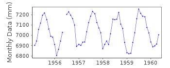
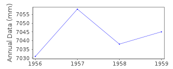
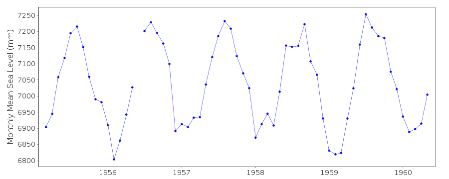
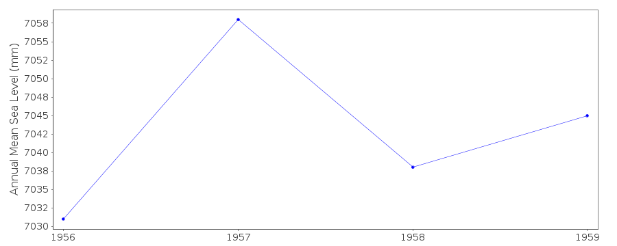
| Time span of data: | 1955 – 1960 |
| Completeness (%): | 86 |
| Date of last update: | 01 Jan 1980 |
| Green Arrow: | Current Station |
| Yellow Marker: | Neighbouring RLR Station |
| Red Marker: | Neighbouring Metric Station |
Please note: In many cases, the station position in our database is accurate to only one minute. Thus, the tide gauge may not appear to be on the coast.
Tide Gauge Data
Station Documentation
Link to RLR information.Documentation added 1991-06-11
Shimonoseki II 647/012 RLR(1959) is 13.1m below BM SimonosekiThis is an historic station last data 1960
Data Authority
Japan Oceanographic Data CentreHydrographic Department, Maritime Safety Agency
MLIT Aomi Building
2-5-18, Aomi, Koto-ku
Tokyo 135-0064

![]()
![]()
![]()
