Data
- Obtaining
- Supplying
- High-Frequency
- Bottom Pressure Records
- Other Long Records
- GLOSS/ODINAFRICA Calibration Data
Donate
Donate to PSMSL
Data Notes
- Individual Station Data and Plot Notes
- Referencing the Data Set
- PSMSL Help File
- 2010 Changes to the PSMSL Data Files
Extracted from Database
20 Jul 2026
Station Information
| Station ID: | 770 |
| Latitude: | 20.9 |
| Longitude: | 70.366667 |
| GLOSS ID: | 31 |
| Coastline code: | 500 |
| Station code: | 21 |
| Country: | INDIA |
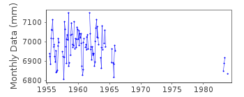
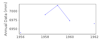
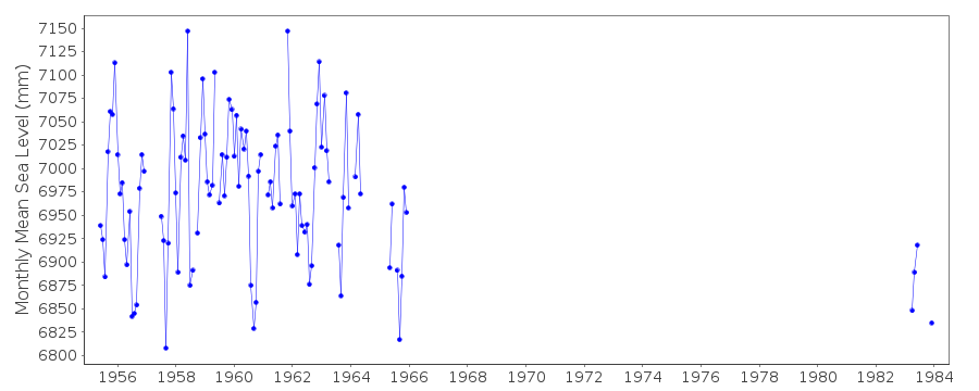
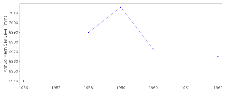
| Time span of RLR data: | 1955 – 1983 |
| RLR completeness (%): | 29 |
| Time span of metric data: | 1955 – 1983 |
| Metric completeness (%): | 47 |
| MTL Data: | 1955-1956 |
| MTL-MSL (mm): | 19 |
| Date of last update: | 27 Jan 2016 |
| Green Arrow: | Current Station |
| Yellow Marker: | Neighbouring RLR Station |
| Red Marker: | Neighbouring Metric Station |
Please note: In many cases, the station position in our database is accurate to only one minute. Thus, the tide gauge may not appear to be on the coast.
Tide Gauge Data
Station Documentation
Link to RLR information.Documentation - date unknown
1955 - 1956 values based on high and low watersDocumentation added 1991-06-11
Veraval 500/021 RLR(1962) is 11.9m below GTS SBM 1955Documentation added 1994-08-04
For a discussion of interannual variability of sea level along the coasts of Pakistan and India, see Clarke and Liu, Journal of Physical Oceanography, 24, 1224, 1994.Documentation added 2002-02-06
Veraval replaced by nearest port Porbandar in Feb. 1997, but was ravaged by cyclone in June 1998 and not yet reconstructed. Unsure when Veraval ceased operating.Documentation added 2002-12-06
SMRC Newsletter Jul-Dec 2001 reports high E coast correlation with SOI and MSL. MSL is much higher during La Nina tropical cyclones than during El Nino.Documentation added 2016-01-26
A value of MTL-MSL=19 mm has been applied to the RLR data for the period 1955-1956. The value was derived using a historic databank of harmonic tidal constants gathered by the International Hydrographic Organization (IHO). Care must be taken when using these IHO constants, though, as there are many known errors in tidal amplitudes and phases.Data Authority
Survey of IndiaGeodetic and Research Branch
17 E.C. Road
Dehra Dun
PIN 248 001

![]()
![]()
![]()
