Data
- Obtaining
- Supplying
- High-Frequency
- Bottom Pressure Records
- Other Long Records
- GLOSS/ODINAFRICA Calibration Data
Donate
Donate to PSMSL
Data Notes
- Individual Station Data and Plot Notes
- Referencing the Data Set
- PSMSL Help File
- 2010 Changes to the PSMSL Data Files
Extracted from Database
13 Jul 2026
Station Information
| Station ID: | 765 |
| Latitude: | 53.4 |
| Longitude: | -3.016667 |
| Coastline code: | 170 |
| Station code: | 201 |
| Country: | UNITED KINGDOM |
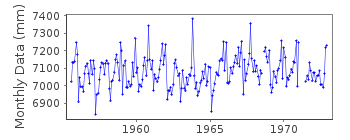
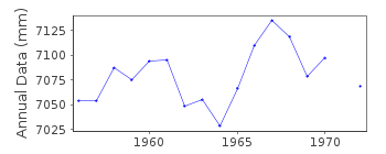
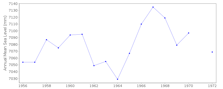
| Time span of RLR data: | 1955 – 1972 |
| RLR completeness (%): | 94 |
| Time span of metric data: | 1955 – 1991 |
| Metric completeness (%): | 49 |
| Date of last update: | 25 Jun 1992 |
| Green Arrow: | Current Station |
| Yellow Marker: | Neighbouring RLR Station |
| Red Marker: | Neighbouring Metric Station |
Please note: In many cases, the station position in our database is accurate to only one minute. Thus, the tide gauge may not appear to be on the coast.
Tide Gauge Data
Additional Data Sources (guide to additional data sources)
Nearby GNSS Stations from SONEL: ALTGNearby Real Time Stations from VLIZ: live2, live
Station Documentation
Link to RLR information.Documentation added 1991-06-11
Birkenhead(Alfred D)170/201 RLR(1964) is 15.0m below TGBM SJ3268 9011Documentation added 1994-09-21
Lege gauge mounted over stilling well and maintained by POLDocumentation added 2001-01-02
Recent work on vertical land movements in the UK can be found from the University of Nottingham web site: http://ukcogr.iessg.nottingham.ac.uk/~eosi/Documentation added 2015-07-23
The TGBM SJ3268 9011 is flush bracket 3978 which is listed as SJ 3267 9011 in the Ordnance Survey database. We believe this is a typing error in the OS database. Whichever SJ location is correct, the same flush bracket is being referred to.Data Authority
British Oceanographic Data CentreNational Oceanography Centre
Joseph Proudman Building, 6 Brownlow Street
Liverpool
L3 5DA

![]()
![]()
![]()
