Data
- Obtaining
- Supplying
- High-Frequency
- Bottom Pressure Records
- Other Long Records
- GLOSS/ODINAFRICA Calibration Data
Donate
Donate to PSMSL
Data Notes
- Individual Station Data and Plot Notes
- Referencing the Data Set
- PSMSL Help File
- 2010 Changes to the PSMSL Data Files
Extracted from Database
13 Jul 2026
Station Information
| Station ID: | 754 |
| Latitude: | 52.473111 |
| Longitude: | 1.750111 |
| Coastline code: | 170 |
| Station code: | 68 |
| Country: | UNITED KINGDOM |
| Time span of data: | 1955 – 2025 |
| Completeness (%): | 93 |
| Date of last update: | 19 Feb 2026 |
| Green Arrow: | Current Station |
| Yellow Marker: | Neighbouring RLR Station |
| Red Marker: | Neighbouring Metric Station |
Please note: In many cases, the station position in our database is accurate to only one minute. Thus, the tide gauge may not appear to be on the coast.
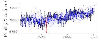
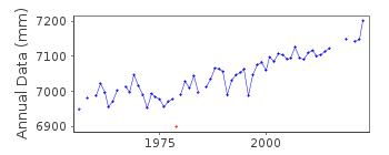
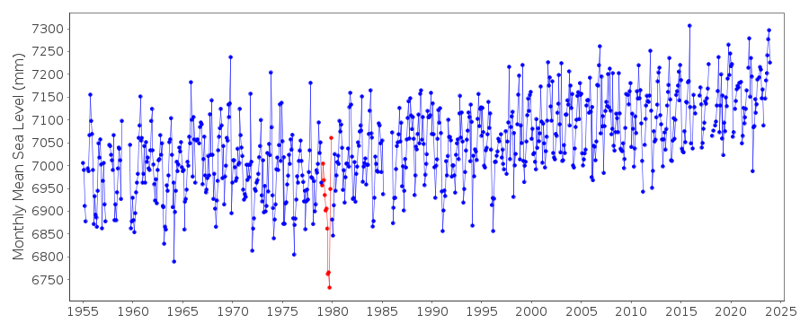
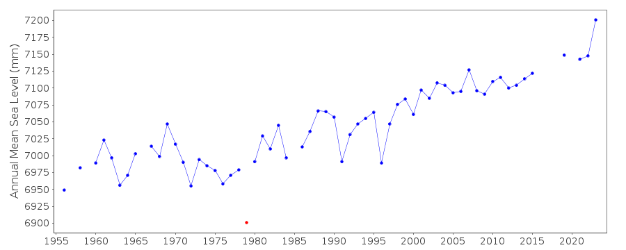
Tide Gauge Data
Additional Data Sources (guide to additional data sources)
Nearby GNSS Stations from SONEL: LOWENearby Real Time Stations from VLIZ: lowe
Station Documentation
Link to RLR information.Documentation added 1991-06-11
Lowestoft 170/068 RLR(1978) is 9.6m below BM TM5477 9272Documentation added 1993-09-27
August-October 1979 datum suspectDocumentation added 1994-09-20
A Lege stilling well gauge was installed in June 1955, replace by Munro and Ott systems in separate wells in May 1970. From February 1985 data have been taken from a potentiometerattached to the Munro stilling well.
Documentation added 1997-07-17
1989 - November 1996: possible error in data of 2-3mm November 1996: new gauge installedDocumentation added 2001-01-02
Recent work on vertical land movements in the UK can be found from the University of Nottingham web site: http://ukcogr.iessg.nottingham.ac.uk/~eosi/Documentation added 2014-07-03
TGI visited the site 04.12.2013 for general maintenance and changed the compressor.Documentation added 2015-05-18
TGI were at site on 02.05.14 and 23.11.14 for General Maintenance.Data Authority
Environment AgencyHorizon House
Deanery Road
BS1 5AH
Bristol

![]()
![]()
![]()
