Data
- Obtaining
- Supplying
- High-Frequency
- Bottom Pressure Records
- Other Long Records
- GLOSS/ODINAFRICA Calibration Data
Donate
Donate to PSMSL
Data Notes
- Individual Station Data and Plot Notes
- Referencing the Data Set
- PSMSL Help File
- 2010 Changes to the PSMSL Data Files
Extracted from Database
20 Jul 2026
Station Information
| Station ID: | 719 |
| Latitude: | 34.716667 |
| Longitude: | -76.733333 |
| Coastline code: | 960 |
| Station code: | 62 |
| Country: | UNITED STATES |
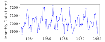
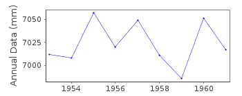
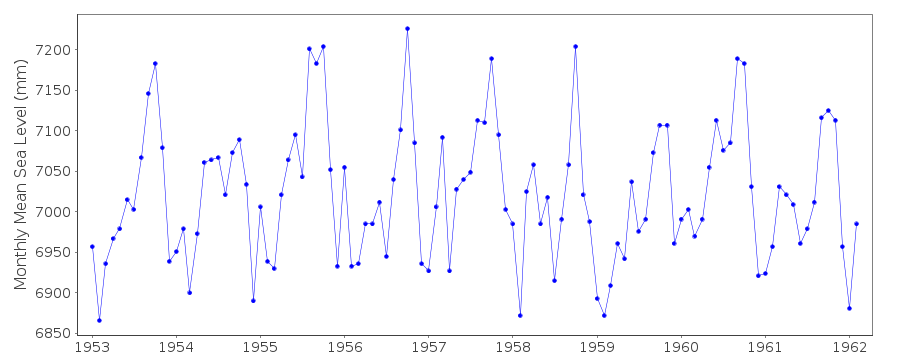
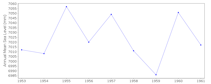
| Time span of data: | 1953 – 1962 |
| Completeness (%): | 92 |
| Date of last update: | 01 Jan 1980 |
| Green Arrow: | Current Station |
| Yellow Marker: | Neighbouring RLR Station |
| Red Marker: | Neighbouring Metric Station |
Please note: In many cases, the station position in our database is accurate to only one minute. Thus, the tide gauge may not appear to be on the coast.
Tide Gauge Data
Additional Data Sources (guide to additional data sources)
Nearby Real Time Stations from VLIZ: benc, benc2Station Documentation
Link to RLR information.Documentation added 1991-06-11
Morehead City 960/062 RLR(1958) is 9.6m below BM1Documentation added 2012-03-01
Morehead City is an Historic station. The last data received was for 1962. There is an entry for Morehead City Harbour, Harbour Channel North Carolina on the NOAA website. This also has B M 1 as one of the benchmarks. However when the datum relationship is calculated it is very different to that on the original RLR diagram.Data Authority
N.O.A.A. / N.O.S.N/oes33, Ssmc4, Room 6531
1305 East-West Highway
Silver Spring,
MD 20910

![]()
![]()
![]()
