Data
- Obtaining
- Supplying
- High-Frequency
- Bottom Pressure Records
- Other Long Records
- GLOSS/ODINAFRICA Calibration Data
Donate
Donate to PSMSL
Data Notes
- Individual Station Data and Plot Notes
- Referencing the Data Set
- PSMSL Help File
- 2010 Changes to the PSMSL Data Files
Extracted from Database
20 Jul 2026
Station Information
| Station ID: | 68 |
| Latitude: | 58.742222 |
| Longitude: | 17.865278 |
| Coastline code: | 50 |
| Station code: | 121 |
| Country: | SWEDEN |
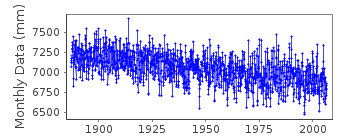
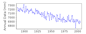
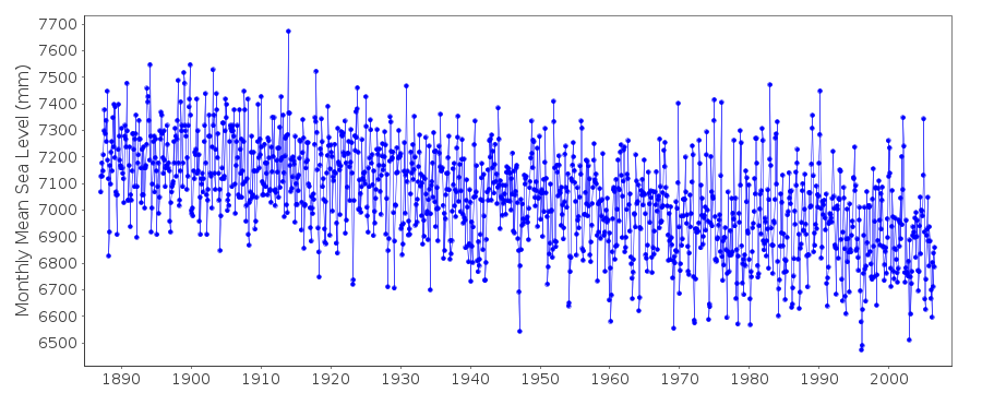
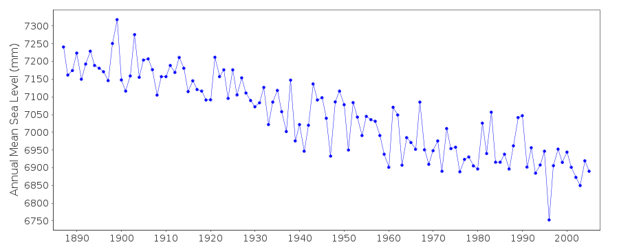
| Time span of data: | 1887 – 2006 |
| Completeness (%): | 100 |
| Date of last update: | 10 Sep 2019 |
| Green Arrow: | Current Station |
| Yellow Marker: | Neighbouring RLR Station |
| Red Marker: | Neighbouring Metric Station |
Please note: In many cases, the station position in our database is accurate to only one minute. Thus, the tide gauge may not appear to be on the coast.
Tide Gauge Data
Additional Data Sources (guide to additional data sources)
Nearby Real Time Stations from VLIZ: landStation Documentation
Link to RLR information.Documentation added 1991-06-11
Landsort 050/121 RLR(1964) is 10.1m below BM No Fix 143J(a)Documentation added 1993-07-12
Landsort 050/121 RLR(1964) is 10.1m below BM No Fix 143J(a)Documentation added 1994-10-19
data for 1987-90 revised in October 1994Documentation added 2010-05-19
Data for 1937-2008 given to 220cm below Swedish Height System 1900 (RH00)Data for 2009 onward given to local datum 713.7cm below RH00
Documentation added 2010-06-09
Beacause of the change in reference datum the RLR value is now 100mm.Documentation added 2012-03-21
Landsort and its replacement Landsort Norra were previously recorded as onedataset. However this is not the case with the SMHI website. The decision was
taken to mirror the SMHI. The two stations have been levelled in one to the
other and so can still be used as one series. From information supplied by
the SMHI the name of the benchmark has changed from No. Fix 146J (a)
to BM c.
Data Authority
Swedish Met. and Hyd. InstituteBox 923
S601 76 Norrkoping

![]()
![]()
![]()
