Data
- Obtaining
- Supplying
- High-Frequency
- Bottom Pressure Records
- Other Long Records
- GLOSS/ODINAFRICA Calibration Data
Donate
Donate to PSMSL
Data Notes
- Individual Station Data and Plot Notes
- Referencing the Data Set
- PSMSL Help File
- 2010 Changes to the PSMSL Data Files
Extracted from Database
13 Jul 2026
Station Information
| Station ID: | 640 |
| Latitude: | 73.933333 |
| Longitude: | 124.5 |
| Coastline code: | 30 |
| Station code: | 440 |
| Country: | RUSSIAN FEDERATION |
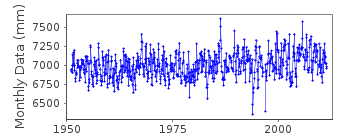
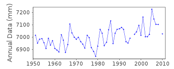
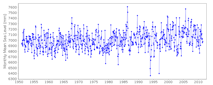
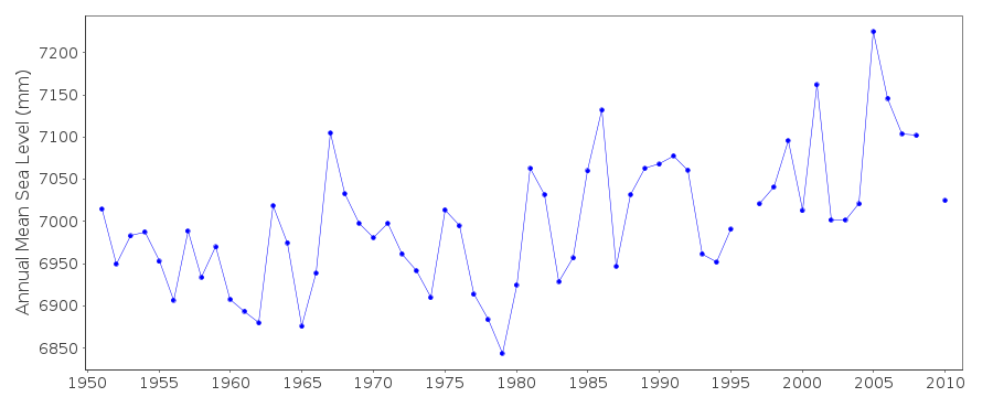
| Time span of data: | 1951 – 2011 |
| Completeness (%): | 98 |
| Date of last update: | 13 Aug 2013 |
| Green Arrow: | Current Station |
| Yellow Marker: | Neighbouring RLR Station |
| Red Marker: | Neighbouring Metric Station |
Please note: In many cases, the station position in our database is accurate to only one minute. Thus, the tide gauge may not appear to be on the coast.
Tide Gauge Data
Station Documentation
Link to RLR information.Documentation added 2010-07-14
Data for Dunai 1951-2000 were previously on the database these data were copied and stored in a box file on top of one of the PSMSL roller front cupboards.A revised dataset 1951-2009 wasdownloaded from the Arctic and Antarctic Research Institute website and loaded onto the database. The RLR factor remains 7.000m as before.
Documentation added 2013-08-13
Following the recent download of data it was noted that some of the historic values differ slightly. Because of this the whole dataset has been re-loaded.Data Authority
Arctic and Antarctic Research InstituteRussian Federal Service
for Hydrometeorology and Environmental Monitoring
36 Bering Street
199397 St. Petersburg
Documentation added 2003-01-23
Instrumental measurements of the sea level in the Russian Arctic Seas began in the 1920s. Stationary observations began in the Kara Sea (Dickson Island) in 1933, in the Laptev Sea (Tiksi Bay) in 1934, in the Chukchi Sea (Cape Schmidt) in 1935, and in the East-Siberian Sea (Ambarchik Bay) in 1939. There were 53 stations with sea level observational program in the mid 1980s. As a results of economical problems in Russia, many stations were closed in the 1990s, and at present, there are 7,7,5 and 2 stations in the Kara, Laptev, East-Siberian and Chukchi Seas, respectively.Observations have been conducted according to the Manual for Stations and Gauges of the Hydrometeorological Service (1968). The observations with manual reading have been carried out four times a day with an accuracy of 1 cm. Tide gauge stations have 1-hour frequency of observations, and the same accuracy. Monthly data quality control includes visual data control and statistical control by the Arctic and Antarctic Research Institute (AARI) scientists and administration of RosHydromet. Observations at some stations have had different locations in summer and winter, some of which were interrupted during replacement.
Therefore a lot of sea level data before 1949-50 in many cases cannot be used because of absence of reliable geodetic survey. All stations have one or more geodetic benchmarks installed on stable ground. Periodic (usually annual but for some stations every summer month) geodetic surveys are made to a gauge to determine if any vertical changes in the gauge mount have occurred. The Russian sea level network has a complete geodetic history consisting of Revised Local Reference (RLR) sites. Only 30-40 years ago, the sea level station benchmarks were related to the Baltic System (Kronshtadt gauge) using geodetic methods.
The monthly sea level data are calculated using daily data. The mean monthly sea level data based on four measurements per day are very close to the observations with 1-hour interval. It is estimated that the error does not exceed 2 cm with probability of 99.7%. The annual sea level based on 4-hour interval observations coincide with results based on 1- hour observing intervals.

![]()
![]()
![]()
