Data
- Obtaining
- Supplying
- High-Frequency
- Bottom Pressure Records
- Other Long Records
- GLOSS/ODINAFRICA Calibration Data
Donate
Donate to PSMSL
Data Notes
- Individual Station Data and Plot Notes
- Referencing the Data Set
- PSMSL Help File
- 2010 Changes to the PSMSL Data Files
Extracted from Database
13 Jul 2026
Station Information
| Station ID: | 568 |
| Latitude: | 28.672022 |
| Longitude: | -17.768686 |
| Coastline code: | 370 |
| Station code: | 15 |
| Country: | SPAIN |
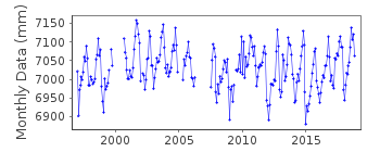
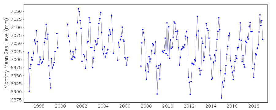
| Time span of RLR data: | 1997 – 2018 |
| RLR completeness (%): | 88 |
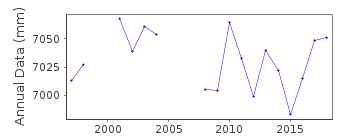
| Time span of metric data: | 1949 – 2018 |
| Metric completeness (%): | 74 |
| Date of last update: | 05 Mar 2019 |
| Green Arrow: | Current Station |
| Yellow Marker: | Neighbouring RLR Station |
| Red Marker: | Neighbouring Metric Station |
Please note: In many cases, the station position in our database is accurate to only one minute. Thus, the tide gauge may not appear to be on the coast.
Tide Gauge Data
Additional Data Sources (guide to additional data sources)
Nearby GNSS Stations from SONEL: LPAL, MAZONearby Real Time Stations from VLIZ: lapa
Research Quality Data from UHSLC station 206: hourly and daily
Station Documentation
Link to RLR information.Documentation added 2000-04-25
S Cruz de la Palma B370/015 RLR(1997) is 10.2m below BM borde metalicoDocumentation added 2008-12-11
Whole dataset replaced by revised values sent from Maria Jesus. Previous values copied and put in file.Documentation added 2010-08-17
Santa Cruz de la Palma is in the Canary Islands.Documentation added 2014-09-03
Using values from a listing recently supplied by IEO the co-ordinates for Santa Cruz de la Palma have been revised.Data Authority
Instituto Español de OceanografíaCorazón de María, 8
28002, Madrid

![]()
![]()
![]()
