Data
- Obtaining
- Supplying
- High-Frequency
- Bottom Pressure Records
- Other Long Records
- GLOSS/ODINAFRICA Calibration Data
Donate
Donate to PSMSL
Data Notes
- Individual Station Data and Plot Notes
- Referencing the Data Set
- PSMSL Help File
- 2010 Changes to the PSMSL Data Files
Extracted from Database
13 Jul 2026
Station Information
| Station ID: | 565 |
| Latitude: | 28.146709 |
| Longitude: | -15.407609 |
| GLOSS ID: | 251 |
| Coastline code: | 370 |
| Station code: | 45 |
| Country: | SPAIN |
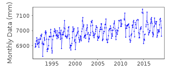
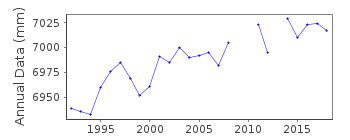
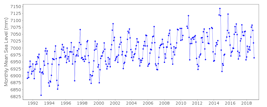
| Time span of RLR data: | 1991 – 2018 |
| RLR completeness (%): | 95 |
| Time span of metric data: | 1949 – 2018 |
| Metric completeness (%): | 67 |
| Link to ellipsoid: | Available |
| Date of last update: | 05 Mar 2019 |
| Green Arrow: | Current Station |
| Yellow Marker: | Neighbouring RLR Station |
| Red Marker: | Neighbouring Metric Station |
Please note: In many cases, the station position in our database is accurate to only one minute. Thus, the tide gauge may not appear to be on the coast.
Tide Gauge Data
Additional Data Sources (guide to additional data sources)
Nearby GNSS Stations from SONEL: PLUZ, ULP2Nearby Real Time Stations from VLIZ: lasp
Fast Delivery Data from UHSLC station 217: hourly and daily
Research Quality Data from UHSLC station 217: hourly and daily
Station Documentation
Link to RLR information.Documentation added 1993-03-31
Data received from TOGA officeDocumentation added 1994-12-14
Data 1983-84 received from TOGADocumentation added 1998-02-24
Data for 1990-91 revised and data for 1990-97 received direct from the Institute of Oceanography Spain1990: gauge at 28 06 N 15 24 W replaced by new equipment at 28 08 N 15 25 W. New equipment is located in the dam of Santa Sofia in the Puerto de la Luz
Documentation added 1999-03-22
Data for 1992-97 revisedDocumentation added 2008-12-11
Database updated with revised values supplied by Maria Jesus. Previous values copied and put in the file.Documentation added 2010-08-17
This Las Palmas (Puerto de la Luz) is on the Canary IslandsDocumentation added 2014-09-03
Using values from a listing recently supplied by IEO the co-ordinates for Las Palmas (Puerto de la Luz) have been revised.Data Authority
Instituto Español de OceanografíaCorazón de María, 8
28002, Madrid

![]()
![]()
![]()
