Data
- Obtaining
- Supplying
- High-Frequency
- Bottom Pressure Records
- Other Long Records
- GLOSS/ODINAFRICA Calibration Data
Donate
Donate to PSMSL
Data Notes
- Individual Station Data and Plot Notes
- Referencing the Data Set
- PSMSL Help File
- 2010 Changes to the PSMSL Data Files
Extracted from Database
13 Jul 2026
Station Information
| Station ID: | 52 |
| Latitude: | 38.683333 |
| Longitude: | -9.416667 |
| GLOSS ID: | 246 |
| Coastline code: | 210 |
| Station code: | 21 |
| Country: | PORTUGAL |
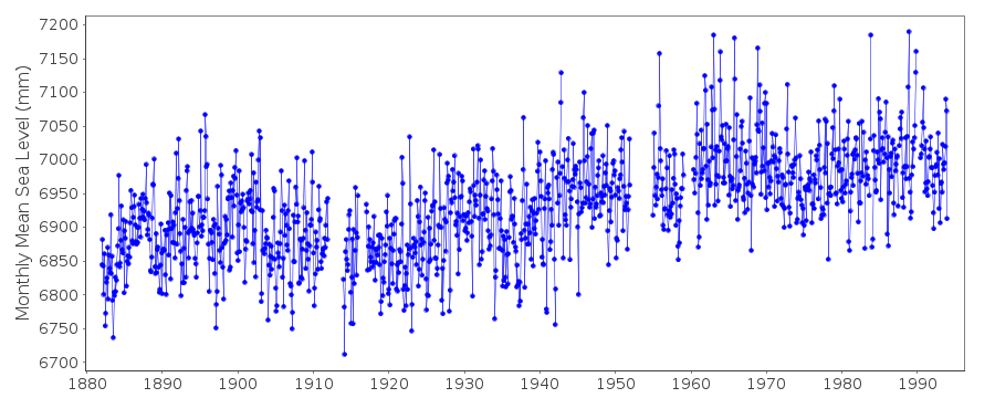
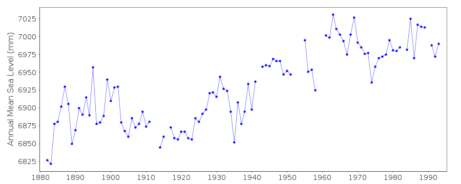
| Time span of data: | 1882 – 1993 |
| Completeness (%): | 93 |
| MTL Data: | 1882-1958 |
| MTL-MSL (mm): | 4 |
| Link to ellipsoid: | Available |
| Date of last update: | 27 Jan 2016 |
| Green Arrow: | Current Station |
| Yellow Marker: | Neighbouring RLR Station |
| Red Marker: | Neighbouring Metric Station |
Please note: In many cases, the station position in our database is accurate to only one minute. Thus, the tide gauge may not appear to be on the coast.
Tide Gauge Data
Additional Data Sources (guide to additional data sources)
Nearby GNSS Stations from SONEL: CASCNearby Real Time Stations from VLIZ: casc
Fast Delivery Data from UHSLC station 209: hourly and daily
Research Quality Data from UHSLC station 209: hourly and daily
Station Documentation
Link to RLR information.Documentation - date unknown
PRIOR TO 1959 MSL VALUES BASED ON READINGS OF HIGH AND LOW WATERDocumentation added 1991-06-11
Cascais 210/021 RLR(1964) is 11.2m below BMOb1Documentation added 1995-10-31
Oct- Nov 1993 values checked and as received from authorityDocumentation added 1997-01-13
data for 1985-87 revised January 1997Documentation added 2001-03-28
Data for 1986-93 updated March 2001Documentation added 2001-04-06
Cascais experienced a small tsunami on 28 February 1969 following a M=7.3 earthquake on the Horseshoe Abyssal Plain at 36 N 11 W.Documentation added 2002-02-05
Cascais 1994-1999 gap due to malfunction.Documentation added 2016-01-22
A value of MTL-MSL=4 mm has been applied to the RLR data for the period 1882-1958. The values were derived using the GESLA2 (high-frequency tide gauge) dataset using harmonic constituents.Data Authority
Instituto Port. de Cartografia e CadastroRua de Artilharia Um, No. 107
P - 1070 Lisboa

![]()
![]()
![]()
