Data
- Obtaining
- Supplying
- High-Frequency
- Bottom Pressure Records
- Other Long Records
- GLOSS/ODINAFRICA Calibration Data
Donate
Donate to PSMSL
Data Notes
- Individual Station Data and Plot Notes
- Referencing the Data Set
- PSMSL Help File
- 2010 Changes to the PSMSL Data Files
Extracted from Database
20 Jul 2026
Station Information
| Station ID: | 503 |
| Latitude: | 31.216667 |
| Longitude: | 29.916667 |
| GLOSS ID: | 349 |
| Coastline code: | 330 |
| Station code: | 71 |
| Country: | EGYPT |
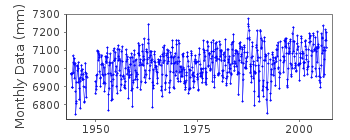
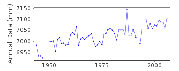
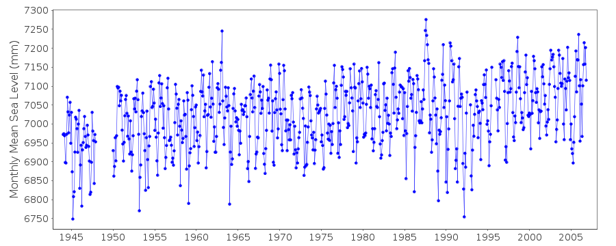
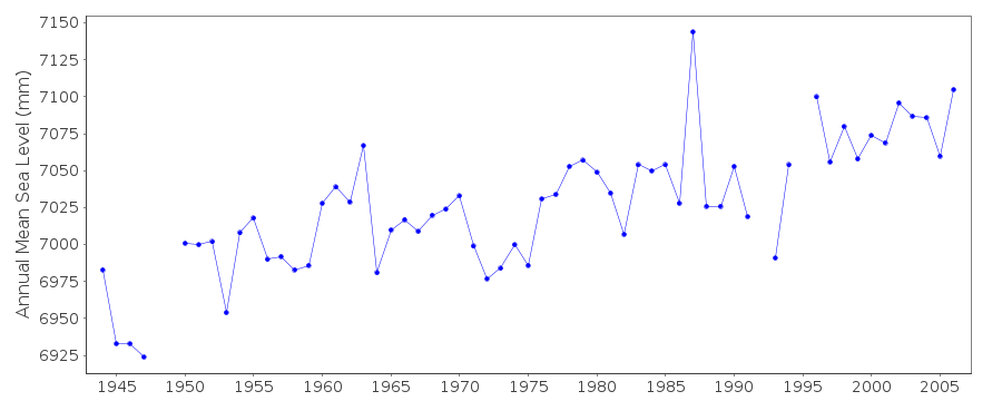
| Time span of data: | 1944 – 2006 |
| Completeness (%): | 96 |
| Date of last update: | 18 Sep 2013 |
| Green Arrow: | Current Station |
| Yellow Marker: | Neighbouring RLR Station |
| Red Marker: | Neighbouring Metric Station |
Please note: In many cases, the station position in our database is accurate to only one minute. Thus, the tide gauge may not appear to be on the coast.
Tide Gauge Data
Additional Data Sources (guide to additional data sources)
Nearby GNSS Stations from SONEL: ALEX, ALX2Nearby Real Time Stations from VLIZ: alex3, alex2
Fast Delivery Data from UHSLC station 807: hourly and daily
Research Quality Data from UHSLC station 807: hourly and daily
Station Documentation
Link to RLR information.Documentation added 1997-10-01
Analysis of Suez Canal data is described by F.M.Eid, S.H.Sharaf El-Din and K.A.Alam El-Din, "Sea-level variation along the Suez Canal",Estuarine, Coastal and Shelf Science, 44, 613-619, 1997. The data 1944-89 is from a float gauge located in the western harbour. These data were provided by Dr. Omran E Frihy of the Coastal Research Institute, Alexandria.Documentation added 2012-10-04
Data for 1944-1989 are from the harbour float gauge located in the Western Harbour and were supplied by Dr. Omran E. Frihy of the Coastal Research Institute of Alexandria. The continuation of the Alexandria data 1990-2006 from the same gauge was supplied by Prof. Mohamed Said of the National Institute of Oceanography and Fisheries (NIOF) Alexandria.Documentation added 2013-09-18
The original data supplied by Frihy were referred to Land Survey Datum (LSD). The Said data on the otherhand referred to datum TGZ. When the two series were amalgamated the difference between the two datums 0.338m was subtracted from the Said dataset. Therefore the whole series now refers to the LSD datum.Data Authority
Coastal Research Institute15 El Pharaana Street
El Shallalat
21514 Alexandria

![]()
![]()
![]()
