Data
- Obtaining
- Supplying
- High-Frequency
- Bottom Pressure Records
- Other Long Records
- GLOSS/ODINAFRICA Calibration Data
Donate
Donate to PSMSL
Data Notes
- Individual Station Data and Plot Notes
- Referencing the Data Set
- PSMSL Help File
- 2010 Changes to the PSMSL Data Files
Extracted from Database
13 Jul 2026
WARNING: QCFLAG EXISTS. PLEASE READ THE DOCUMENTATION.
Station Information
| Station ID: | 5 |
| Latitude: | 53.313944 |
| Longitude: | -4.620444 |
| Coastline code: | 170 |
| Station code: | 191 |
| Country: | UNITED KINGDOM |
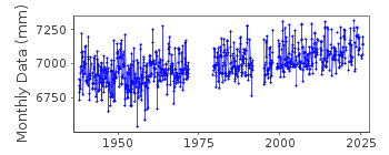
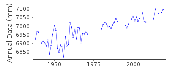
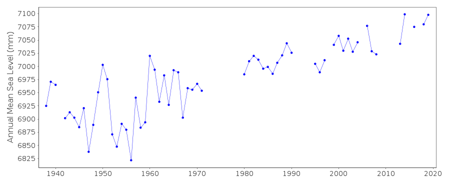
| Time span of RLR data: | 1938 – 2025 |
| RLR completeness (%): | 81 |
| Time span of metric data: | 1838 – 2025 |
| Metric completeness (%): | 40 |
| MTL Data: | 1938-1959 |
| MTL-MSL (mm): | -32 |
| Date of last update: | 19 Feb 2026 |
| Green Arrow: | Current Station |
| Yellow Marker: | Neighbouring RLR Station |
| Red Marker: | Neighbouring Metric Station |
Please note: In many cases, the station position in our database is accurate to only one minute. Thus, the tide gauge may not appear to be on the coast.
Tide Gauge Data
Additional Data Sources (guide to additional data sources)
Nearby GNSS Stations from SONEL: HOLYNearby Real Time Stations from VLIZ: holy2
Station Documentation
Link to RLR information.Documentation added 1991-06-11
Holyhead 170/191 RLR(1988) is 12.1m below BM SH2520 8296Documentation added 1994-07-20
Between 1926-1950 gauge was a Harrison type, replaced by a Lea in 1958, and a Munro/Ott combination in July 1978. From August 1984 the gauge has been an "A Class" bubbler. Gauge destroyed by a ship in 1991 and reinstalled in 1995Documentation added 1996-09-30
Data for 1938-59 are mean tide levels, whereas data for 1960-62 are MSL based on 8 measurements per day, and then MSL based on 24 per day. At Holyhead, MTL will be approximately 3.2cm BELOW MSL, based on the contribution from the M4 tidal constituent only. The PSMSL data have NOT been corrected for this systematic offset. It can be seen that, even with this correction, there is still an apparent datum shift around 1960 (see report of Lennon and Rossiter) Data prior to 1960 came from the LMS Railway Company and was considerably noisier, compared to data from Newlyn, for example than data from 1960 onwards which was computed at POL. (Superseded by new entry on 26-Jan-2016)Documentation added 2001-01-02
Recent work on vertical land movements in the UK can be found from the University of Nottingham web site:http://ukcogr.iessg.nottingham.ac.uk/~eosi/Documentation added 2001-02-13
Holyhead channel 2 - Spare pressure point fitted 22/Dec/97, subsequently data reading 2cms higher. Also, pneumatics becoming blocked with marine growth, not cleared until 6/Feb/99. Thereafter data assumed to be to previous datum. Data December 1997 - January 1999 inclusive not used.Documentation added 2009-01-28
Treat data 1960 onwards with caution.Documentation added 2014-07-03
TGI visited the site a number of times during 2013. on the 13.03.2013 site was levelled and calibration checks made. 11.06.2013 General maintenance was carried and and the compressor changed. 03.07.2013 The gauge was serviced to improve data quality. 18.11.2013 The radar gauge was removed for testing and on 17.12.2013 testing was carried out on the installed radar gauge.Documentation added 2015-05-18
TGI visited the site 6 times in total during 2014. There were intermittant issues with channels blocking during August and October on 18.08.14 the TGI visited to resolve the problem with channel 2. While there they removed the radar from channel 1 and re-instated the float gauge.On 12.10.14 TGI again visited to clear the blocked bubbler channel and the float gauge was serviced.Documentation added 2016-01-26
A value of MTL-MSL=-32 mm has been applied to the RLR data for the period 1938-1959. The values were derived using the GESLA2 (high-frequency tide gauge) dataset using harmonic constituents. The value also agrees with the estimate published in Woodworth et al., GJI, 136, 651–670, 1999.Data Authority
Environment AgencyHorizon House
Deanery Road
BS1 5AH
Bristol

![]()
![]()
![]()
