Data
- Obtaining
- Supplying
- High-Frequency
- Bottom Pressure Records
- Other Long Records
- GLOSS/ODINAFRICA Calibration Data
Donate
Donate to PSMSL
Data Notes
- Individual Station Data and Plot Notes
- Referencing the Data Set
- PSMSL Help File
- 2010 Changes to the PSMSL Data Files
Extracted from Database
13 Jul 2026
Station Information
| Station ID: | 476 |
| Latitude: | 14.633333 |
| Longitude: | -17.45 |
| GLOSS ID: | 253 |
| Coastline code: | 390 |
| Station code: | 1 |
| Country: | SENEGAL |
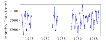
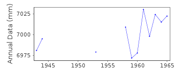
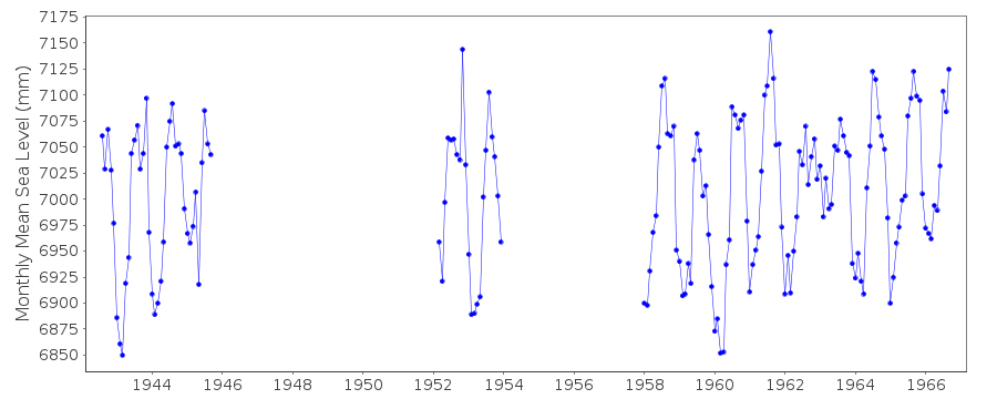
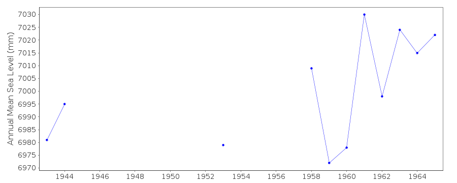
| Time span of data: | 1942 – 1966 |
| Completeness (%): | 55 |
| Link to ellipsoid: | Available |
| Date of last update: | 01 Jan 1980 |
| Green Arrow: | Current Station |
| Yellow Marker: | Neighbouring RLR Station |
| Red Marker: | Neighbouring Metric Station |
Please note: In many cases, the station position in our database is accurate to only one minute. Thus, the tide gauge may not appear to be on the coast.
Tide Gauge Data
Additional Data Sources (guide to additional data sources)
Nearby GNSS Stations from SONEL: DAKA, DATG, DAKRFast Delivery Data from UHSLC station 223: hourly and daily
Research Quality Data from UHSLC station 223: hourly and daily
Station Documentation
Link to RLR information.Documentation added 1991-06-11
Dakar 390/001 RLR(1965) is 8.3m below Repere FondamentalDocumentation added 1993-07-12
Dakar 390/001 RLR(1965) is 8.3m below Repere FondamentalDocumentation added 2008-11-03
Following information from Guy Woppelmann the RLR diagram for Dakar was redrawn to show the relationship between benchmarks Nr.0 bis,Nr.0 and Nr.21. The UH TGZ is the same as the French Zero Hydrographique.Data Authority
SHOM13 rue de Chatelier
29200 BREST

![]()
![]()
![]()
