Data
- Obtaining
- Supplying
- High-Frequency
- Bottom Pressure Records
- Other Long Records
- GLOSS/ODINAFRICA Calibration Data
Donate
Donate to PSMSL
Data Notes
- Individual Station Data and Plot Notes
- Referencing the Data Set
- PSMSL Help File
- 2010 Changes to the PSMSL Data Files
Extracted from Database
13 Jul 2026
Station Information
| Station ID: | 474 |
| Latitude: | 49.929096 |
| Longitude: | 1.083812 |
| Coastline code: | 190 |
| Station code: | 31 |
| Country: | FRANCE |
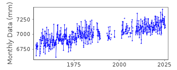
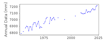
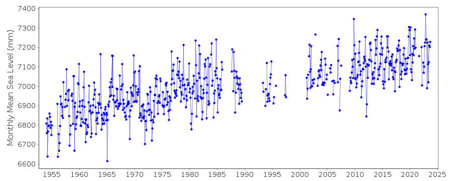
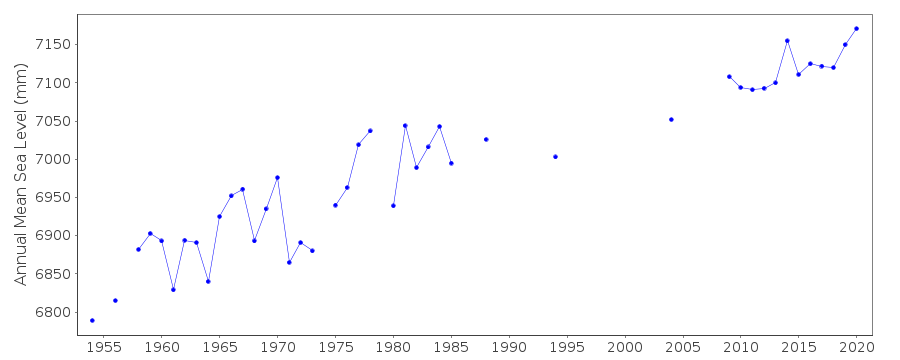
| Time span of RLR data: | 1954 – 2025 |
| RLR completeness (%): | 75 |
| Time span of metric data: | 1942 – 2025 |
| Metric completeness (%): | 66 |
| Date of last update: | 20 Feb 2026 |
| Green Arrow: | Current Station |
| Yellow Marker: | Neighbouring RLR Station |
| Red Marker: | Neighbouring Metric Station |
Please note: In many cases, the station position in our database is accurate to only one minute. Thus, the tide gauge may not appear to be on the coast.
Tide Gauge Data
Additional Data Sources (guide to additional data sources)
Nearby GNSS Stations from SONEL: CTZ3, DIPP, AMBL, CT3BNearby Real Time Stations from VLIZ: diep2, diep
Station Documentation
Link to RLR information.Documentation - date unknown
Metric data for 1942 supplied by B.O.D.C.Documentation added 1991-06-11
Dieppe 190/031 RLR(1977) is 12.4m below BM NGFNCP3.2Documentation added 1994-07-11
Informal information suggests local sinking near gauge.Documentation added 2010-08-24
Tide gauge re-instated 2009 TGBM and Chart Datum remain the same see email from Ronan Creach 19.08.10. Therefore the RLR factor remains 2.070m.Documentation added 2012-03-27
The data following the gauges re-installation in 2009 appears to be slightly higher than previous. However, when the data for Dieppe is buddy checked with both Le Havre and Boulogne the data following the gap appears to be in better agreement.Documentation added 2014-09-24
Using values from the SONEL website the latitude and longitude values for Dieppe have been revised.Documentation added 2014-09-29
New data points have been added to the data for Dieppe in particular data has been added for the period 1993-2007. Because of this the whole dataset has been re-loaded.Documentation added 2025-07-15
Updated the whole dataset to ensure they include all the historical data recovered recently by SHOM and the calculated monthly and annual means match those distributed by SONEL.Data Authority
SHOM13 rue de Chatelier
29200 BREST

![]()
![]()
![]()
