Data
- Obtaining
- Supplying
- High-Frequency
- Bottom Pressure Records
- Other Long Records
- GLOSS/ODINAFRICA Calibration Data
Donate
Donate to PSMSL
Data Notes
- Individual Station Data and Plot Notes
- Referencing the Data Set
- PSMSL Help File
- 2010 Changes to the PSMSL Data Files
Extracted from Database
13 Jul 2026
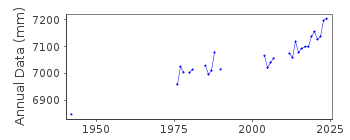
Station Information
| Station ID: | 471 |
| Latitude: | 50.727501 |
| Longitude: | 1.57746 |
| Coastline code: | 190 |
| Station code: | 21 |
| Country: | FRANCE |
| Time span of data: | 1941 – 2025 |
| Completeness (%): | 45 |
| Date of last update: | 20 Feb 2026 |
| Green Arrow: | Current Station |
| Yellow Marker: | Neighbouring RLR Station |
| Red Marker: | Neighbouring Metric Station |
Please note: In many cases, the station position in our database is accurate to only one minute. Thus, the tide gauge may not appear to be on the coast.
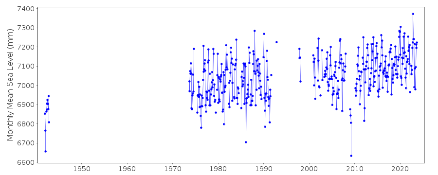
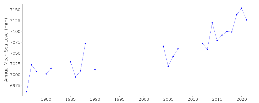
Tide Gauge Data

Additional Data Sources (guide to additional data sources)
Nearby GNSS Stations from SONEL: EQH2, EQHENearby Real Time Stations from VLIZ: boul2, boul
Station Documentation
Link to RLR information.Documentation - date unknown
1942 DATA SUPPLIED BY AUTH. CODE 66Documentation added 1991-06-11
Boulogne 190/021 RLR(1976) is 13.0m below RepereA(1976)Documentation added 1993-07-22
readings discontinued october 1991Documentation added 2010-05-17
There is no data for 2008 and very little data for 2009. The data for 2009 has been flagged as suspect as it looks too low.Documentation added 2011-02-01
With updated information available from both the SHOM and SONEL websites the RLR diagram for Boulogne has been re-drawn. Primary benchmark is now N.BC - 15 10.679m above TGZ (Zero Hydrographic). IGN 69 is 4.388m above TGZ. As the datum remains the same the RLR factor remains 2.090m.Documentation added 2014-09-29
A number of additinal data values for 1987 have been added to the dataset. To incorporate these the whole dataset has been reloaded.Documentation added 2025-07-15
Updated the whole dataset to ensure they include all the historical data recovered recently by SHOM and the calculated monthly and annual means match those distributed by SONEL.Data Authority
SHOM13 rue de Chatelier
29200 BREST

![]()
![]()
![]()
