Data
- Obtaining
- Supplying
- High-Frequency
- Bottom Pressure Records
- Other Long Records
- GLOSS/ODINAFRICA Calibration Data
Donate
Donate to PSMSL
Data Notes
- Individual Station Data and Plot Notes
- Referencing the Data Set
- PSMSL Help File
- 2010 Changes to the PSMSL Data Files
Extracted from Database
20 Jul 2026
Station Information
| Station ID: | 467 |
| Latitude: | 49.651299 |
| Longitude: | -1.63563 |
| Coastline code: | 190 |
| Station code: | 61 |
| Country: | FRANCE |
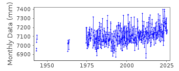
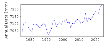
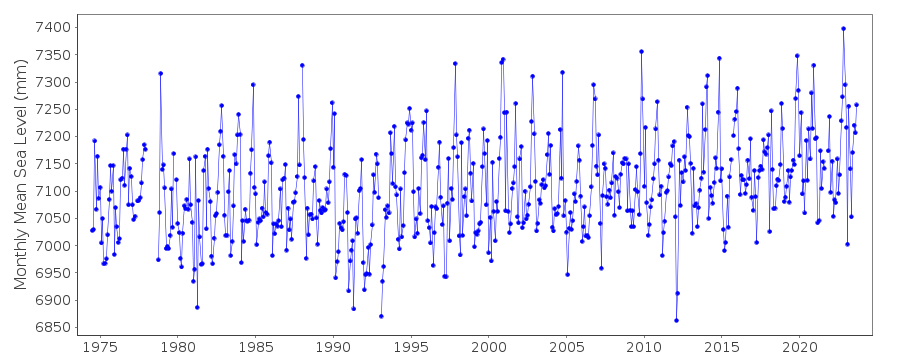
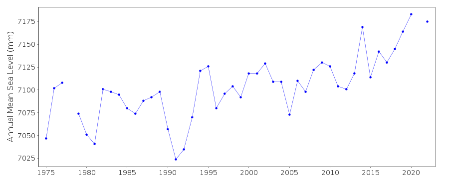
| Time span of RLR data: | 1943 – 2025 |
| RLR completeness (%): | 61 |
| Time span of metric data: | 1942 – 2025 |
| Metric completeness (%): | 63 |
| Date of last update: | 20 Feb 2026 |
| Green Arrow: | Current Station |
| Yellow Marker: | Neighbouring RLR Station |
| Red Marker: | Neighbouring Metric Station |
Please note: In many cases, the station position in our database is accurate to only one minute. Thus, the tide gauge may not appear to be on the coast.
Tide Gauge Data
Additional Data Sources (guide to additional data sources)
Nearby GNSS Stations from SONEL: BMHG, HEAU, CHTGNearby Real Time Stations from VLIZ: cher2, cher
Station Documentation
Link to RLR information.Documentation - date unknown
1943 DATA SUPPLIED BY AUTHORITY NO. 661942,1944,1960-1962 DATA SUPPLIED BY AUTHORITY NO.19
Documentation added 1991-06-11
Cherbourg 190/061 RLR(1975) is 12.5m below BMNGFNPQ35Documentation added 1993-07-12
Cherbourg 190/061 RLR(1975) is 12.5m below BMNGFNPQ35Documentation added 2014-09-24
Using values from the SONEL website the latitude and longitude values have been revised. The SONEL data included additional data points for October 1976,October 1978,December 1985,August-December 1994 and January-November 2009. These have been added to the database.Documentation added 2016-06-21
When loaded the 2015 dataset it was noted that the datapoint for October 2012 had been revised.Documentation added 2025-07-15
Updated the whole dataset to ensure they include all the historical data recovered recently by SHOM and the calculated monthly and annual means match those distributed by SONEL.Data Authority
SHOM13 rue de Chatelier
29200 BREST

![]()
![]()
![]()
