Data
- Obtaining
- Supplying
- High-Frequency
- Bottom Pressure Records
- Other Long Records
- GLOSS/ODINAFRICA Calibration Data
Donate
Donate to PSMSL
Data Notes
- Individual Station Data and Plot Notes
- Referencing the Data Set
- PSMSL Help File
- 2010 Changes to the PSMSL Data Files
Extracted from Database
20 Jul 2026
Station Information
| Station ID: | 466 |
| Latitude: | 46.158478 |
| Longitude: | -1.220736 |
| Coastline code: | 190 |
| Station code: | 121 |
| Country: | FRANCE |
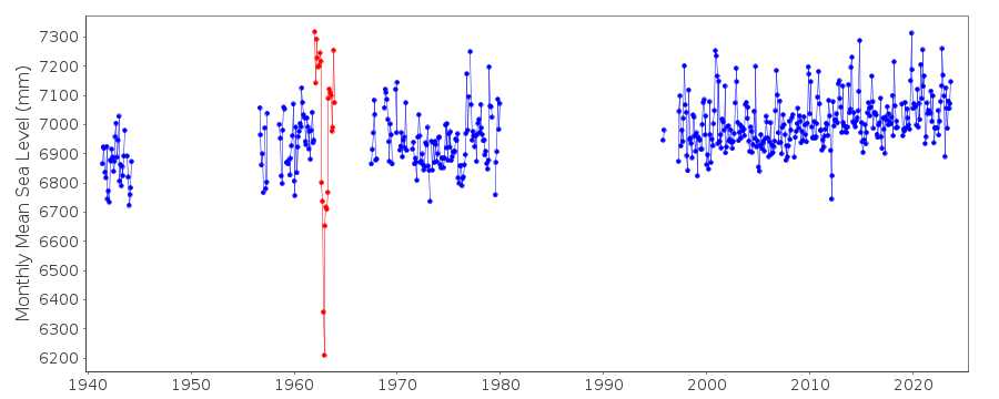
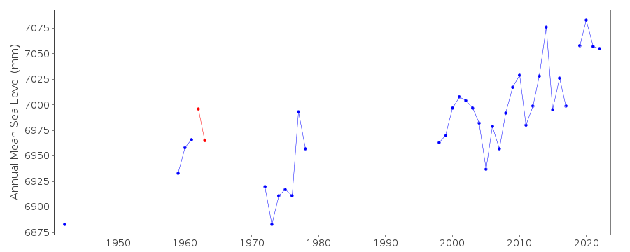
| Time span of data: | 1941 – 2025 |
| Completeness (%): | 48 |
| Link to ellipsoid: | Available |
| Date of last update: | 20 Feb 2026 |
| Green Arrow: | Current Station |
| Yellow Marker: | Neighbouring RLR Station |
| Red Marker: | Neighbouring Metric Station |
Please note: In many cases, the station position in our database is accurate to only one minute. Thus, the tide gauge may not appear to be on the coast.
Tide Gauge Data
Additional Data Sources (guide to additional data sources)
Nearby GNSS Stations from SONEL: LROCNearby Real Time Stations from VLIZ: larp, larp2
Station Documentation
Link to RLR information.Documentation - date unknown
1942 data supplied by B.O.D.C.DATA SUPPLIED BY AUTHORITY NO. 661956-1963 data supplied by the National Geographical Institute, France
Documentation added 1991-06-11
La Pallice 190/121 RLR(1978) is 12.2m below BM C1(NGFN.6)1966Documentation added 1993-03-16
There are anomalously low values for Oct 62 - April 63.Documentation added 2001-12-06
New acoustic gauge installed at La Pallice 28/4/1997 at 4609N 00113W (prev. 4610N). This was replaced by a radar (Krohne BM70) gauge on 23/4/2001.Documentation added 2012-03-29
Name of the Primary benchmark has been changed to IGN O.O.K3 - 126 9.107m above Zero Hydrographique.Documentation added 2014-09-24
Using values from the SONEL website the latitude and longitude for La Rochelle have been revised. The downloaded data from SONEL contained some additional data points particularly for the early 1940's. Because of this the complete dataset has been reloaded.Documentation added 2025-07-15
Updated the whole dataset to ensure they include all the historical data recovered recently by SHOM and the calculated monthly and annual means match those distributed by SONEL.Data Authority
SHOM13 rue de Chatelier
29200 BREST

![]()
![]()
![]()
